![]()
| • Home | •• Remote Sensing | ••• Global Positoning System (GPS) Survey | •••• GPS 3D |
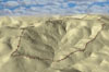 |
Simulation of Kerkenes made in ArcView 3D Analyst and Adobe Photoshop. |
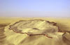 |
Simulation of Kerkenes made in ArcView 3D Analyst and Adobe Photoshop looking from south. |
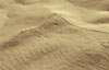 |
3D view of the northern part of the city created from GPS data. |
![]()
|
|
|
• Introduction
• Selected Images
• History
• Exploration • Remote Sensing • Excavations • Finds • GIS • The City • Regional Survey • Preliminary Reports • Project Publications • Bibliography |