| |
Structures are
accurately located from the resistivity plans in such a way that the coordinates
of building corners can be precisely determined. Once the four corners
of a building under investigation have been marked on the ground trenches
can be positioned so that rooms can be excavated a quarter or half at
a time, thereby permitting the recording of sections along central axes
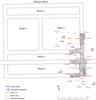
(Figs 28
and 31).
Excavation
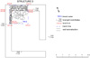
of the Megaron and Associated Structures in Trenches TR06 to TR10
Resistivity
survey in the central zone of the lower part of the city had revealed
what appeared to have been a large compound or urban block within which
a number of well preserved building plans could be readily identified.
Of these buildings, some would seem to be distinctively different to structures
seen elsewhere in the city. Following a pattern established in earlier
seasons, for the purpose of reports and publications each recognisable
structure within a definable complex or block was given a letter code
beginning with A. Each Structure is then given its own set of room numbers
and wall numbers, in both cases beginning with 1. These designations,
which are regardless of Trenches or excavation "units", are
given once fieldwork is well advanced or has been completed. This procedure
is possible because buildings are generally well defined on remote sensing
imagery as well as being relatively straightforward to excavate.
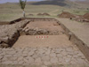
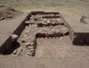
Of specific interest, not least because of their Anatolian connotations,
were what seemed clearly to be two large megarons, i.e. buildings comprising
a large main room with a central hearth and an open porch at the front.
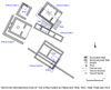
These were labelled Structures A (trench TR06) and B (not excavated) (Figs
1,
9
and 28).
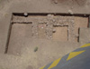
Structure C (Fig. 31)
appears to comprise a row of three or more rooms, orientated approximately
east-north-east by west-south-west, located between the megarons in a
way that might seem to sub-divide the entire compound into two discrete
spaces, each of which would perhaps have been dominated by one of the
megarons. Similar rows of cell-like rooms can be identified on the geophysical
imagery in very many parts of the city, and one had been partially excavated
at the northern end of test trench TT15 in 1996 and completed in test
trench TT20 in 1998. The function(s) of these rows of cells is of interest,
not least because of their almost ubiquitous presence in the urban blocks
over the lower portion of the city and the concomitant implications for
reaching a greater understanding of how the "urban blocks" might
have functioned. It was anticipated that these particular rooms would
be well preserved and they might, therefore, contain evidence that was
pertinent to their use at the time of the destruction and abandonment.
In terms of the plan, the location doors would provide a clear indication
as to whether this row of buildings was associated with the megaron to
the north (Structure A) or with that to the south-west (Structure B).
Yet another aspect to be investigated was the stratigraphic relationship
between each of the Structure C rooms themselves as well as between the
row of rooms and associated structures. In this last respect it will be
of special interest, in the longer term, to attempt establish the sequential
relationship between each of the two megarons and this row of cells which
itself defines and makes discrete the open spaces in front of each building.
The second megaron, Structure B, apparently possess small additional features,
notably at the rear, which might perhaps indicate that it was the first
to have been built.
Structure D (Figs 28,
36
and 37),
situated behind and partially to one side of Structure A, comprises a
rectangular building with what appears to have been a door in the south-eastern
corner.
Structure E (Figs 28
and 38,
39,
40)
is a large two-roomed building with narrow magazine-like rooms along each
side, lies adjacent to the central portion of the south-western wall of
the compound. The two large rectangular rooms were seen to be flanked
by long, narrow, magazines and appeared to have an extension on the south
side that had encroached on open space beyond the block. This interpretation
was fully confirmed by excavation.
Other walls and rooms visible on the geophysical imagery are less easily
defined and, as a consequence, have not yet been assigned to Structures.
One of primary reason for choosing for investigation this particular location
within the lower portion of the city, apart from the seemingly exceptional
buildings, was the element in the overall research design that envisaged
the provision of running water, via gravity feed from a çesme,
for trench-side wet sieving (Fig. 41)
and flotation as well as for dampening the soil during excavation.
Methods
and Progress
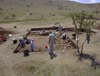
Trenches
were laid out according to the plans of the buildings as they appeared
on the resistivity map. In large rooms one quarter is excavated at a time
while smaller rooms are half excavated with, in all cases, sections maintained
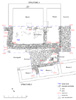
along the central axes of each structure. Trench TR06 was positioned so
as to reveal the south-western half of a megaron, Structure A. This was
done in two stages so that a section was cut through the middle of the
main room at ninety degrees to the central axis. Trench TR07 was laid
out so that the north-east quarter of the north-western room and north-west
quarter of what appeared to be the central room would be excavated together
with a strip of the external surface on the north-eastern side. Trench
TR07 was subsequently expanded in two stages, firstly to join it with
trench TR06 and secondly to the south-east in order to reveal the wall
running between the megaron (Structure A) and Structure C. It proved possible
to lay out the trenches in such a way that trench TR06 was precisely aligned
with central axis of the megaron, while trench TR07 was exactly parallel
with the long axis of Structure C, negating any need for adjustment.
On completion of excavation it was possible, through the kind offices
of the Mayor of Sorgun, to have the loan of a TEDAS lorry with an extendable
arm from which high-level photographs could be taken. In addition to these
overall photographs, a full digital record was made of all wall tops and
faces for possible future use in making simulations or rectified images.
This photographic record was in addition to the normal procedure of systematically
drawing detailed plans, sections and elevations at a scale of 1:20.
At the end of the season the trenches were lined with geotextile and refilled
with earth.
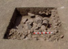
Finds from Trenches in the Lower Central Area
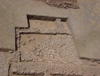
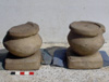
Two ornate and unusual biconical sandstone column bases or, perhaps, offering
tables, are of not inconsiderable architectural interest. The square bases
have curved sides and drafted margins on the top, the drums are biconical
supporting circular recessed seating. The pieces are very similar but
not identical.
Conclusions on work done in the central area
Interpretation of the resistivity imagery proved to have been very accurate
in this area with the result that plans of the larger area of survey can
now be drawn up with considerable confidence.
The identification
of two megarons, i.e. buildings with double pitched roofs comprising a
single large room with a central hearth and an open porch, was indisputably
confirmed by excavation. On the other hand, the function of the megarons
and the associated structures within this special compound or urban block
has not been resolved with complete satisfaction. None of the excavated
buildings were found to contain domestic installations, nor was any evidence
for everyday domestic activity discovered. The recovery of three tripod
footed stone bowls (Figs 43
and 44
plus one not illustrated), a number of pottery lids (two shown on Fig.
45)
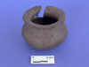
and a few other poorly preserved pottery vessels (Figs 46
and 47)
might point towards some special public function for these distinctive
buildings, although further support for such a function is best found
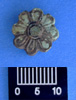
in the negative evidence for recognisable activity. The recovery of an
ornate rosette headed tack (Fig. 48)
and a small stone inlay of a feather, as well as fragments of one or more
stone trinket moulds, while of intrinsic interest in their own right,
are of little help in determining the function of this area and its special
buildings since none were recovered from primary contexts. The absence
of charred floral and faunal remains was not unexpected because similar
results had been obtained in test trenches dug in 1996, although it had
been hoped that there would have been a greater depth of deposit in this
low central area of the city. The complete absence of architectural decorative
tiles is a negative result of wider significance (as discussed earlier
in this report).
Another conclusion of some importance is the extent of the building activity.
In trenches TR06 and TR07 it is possible to recognise a minimum of four
structural phases. Building activity in this area of the city can be seen
therefore to have spanned some considerable time, although not so long
that buildings had (obviously) begun to collapse from age.
|
|