 |
 |
 |
 |
 |
| Fig. 15 |
Fig. 16 |
Fig. 17 |
Fig. 18 |
Fig. 19 |
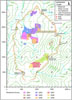
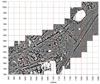
Geophysical survey was conducted over the high southern ridge (Figs 15 and 16). The area extends from the base of the stone glacis at the eastern end of the Palatial Complex to the terraces at the foot of the south-west side of the Kale east of the Field and northwards to where the terrain begins to drop steeply towards the lower sectors of the city.
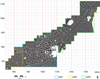
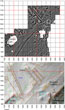
A Geoscan RM15 was used for the electrical resistance survey in 20 by 20m grids with a sampling strategy of readings every 0.50m at 0.50m traverse intervals in zig-zag mode (Figs 17 and 18). Data was collected for a total of 142 grids covering an area of 56,800 square metres, a little more than five and a half hectares. As anticipated, results were of the high clarity that one expects at Kerkenes. The unusually damp conditions provided by much needed heavy spring rainfall facilitated the survey where the ground normally dries up very rapidly after the winter snow cover has melted.
The Area by the Palatial Complex Glacis
The area immediately in front of the glacis at the eastern end of the Palatial Complex, as also demonstrated by earlier geomagnetic survey, is devoid of buildings (Figs 18 and 19). This is one of the few large unencumbered public spaces within the entire city.
Reservoirs
The Leech Pond or Sülüklü Göl (Figs 20 and 21), so named on account of its population of the European medicinal leech, has long been recognised as an important and perhaps focal feature within the public zone at the southern part of the capital. There is local inconsistency in the naming of ponds, with the Sülüklü Göl sometimes being referred to as the At Gölü (Horse Pond). Resistance survey confirmed an absence of structures within the enclosed space around the Leech Pond while, in a new revelation, showing two reservoirs each with artificial banking and a central sluice, on slightly more elevated terraces to the west of the main stone-lined facility (Fig. 19). It is not yet clear whether these newly identified reservoirs fed into the main one or were entirely independent. In any event, they further highlight the importance of water management within the city.
'Royal Stables'
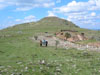
Work spread over several years since the first season of the current investigations at Kerkenes in 1993 has investigated a series of large, prominent features (Figs 20 and 21) located below the south-western side of the ancient acropolis, known as Keykavus Kale, and facing what we have called the Cappadocia Gate. The idea that the two large parallel structures on the terraces above the Field might have been stables was mooted in the first, 1993, season.
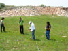
For this reason a two-metre wide test trench, TT19, was excavated across the terraces in 1996 in cooperation with Musa Özcan, then Director of the Yozgat Museum. Geomagnetic survey with a Geoscan FM36 fluxgate gradiometer was conducted over these terraces in 2000 while electrical resistance survey was done with a Geoscan RM15 in 2009.
Location within the City
The features discussed here are located on the high southern ridge of the city between the substantial and very largely destroyed public structures that stood on the rocky terraces below and to the southwest of the acropolis and the stone-lined reservoir known as the Sülüklü Göl. The gate called by us the Cappadocia Gate, perhaps the most important of the seven city gates (Fig. 15), lies opposite, on the far side of the main street that runs from the East Gate past the Palatial Complex to the Gözbaba Gate. The major street leading from the Cappadocia Gate to the lower sectors of the city passes above, i.e. on the north-eastern side, of the uppermost structure. Thus these public structures are situated at the crossing of the two most important streets within the city which, according to Scott Branting's predictive models, would have carried the greatest volumes of traffic.
Architectural Considerations
One major consideration that would have needed to be addressed in designing stables at Kerkenes was the bitterly cold winters. A second and equally important consideration would have been aeration, particularly in the short hot summer months.
The roof span of each of the two stable buildings was approximately 20 metres. In this respect it is worth noting that a number of large halls with similarly wide spans are known at Kerkenes. These buildings were covered with pitched roofs of reeds supported by two rows of substantial wooden posts resting on stone bases. Equally large buildings appear to have been similarly roofed as early as the ninth century BC at Gordion. However, posts supporting the pitched roofs over the largest of the pre-destruction megarons at the Phrygian capital rested on wooden sleeper beams rather than individual post bases. The pitch of a thatched roof in a region prone to heavy falls of snow could hardly have been less that 40°, in which case the apex of the pediment would have approached eight metres in height. It might thus be imagined that the buildings attained a total height approaching or in excess of 12 metres. While positive evidence for post bases has yet to be found, it is known that stone bases are not generally identifiable on geophysical imagery at Kerkenes, presumably because, in contrast to linear features such as wall foundations, they are not distinguishable from the stone rubble terrace fill in which they sit.
Phosphate Analysis
Soil samples were taken for phosphate analysis to be carried out in the Central Research Laboratories at METU by Prof. Cemal Göncüoğlu. Some samples were taken from within the stables themselves while others were collected from the Field, the long structure flanking the southwest edge of the field and the main street above the terraces. In most cases it appeared that erosion had exposed the subsoil, an observation that had already been made in test trench TT19. Samples were taken by burrowing a few centimetres into the ground avoiding or removing plant roots in as far as was possible. Where stone paving had been revealed in test trench TT19 samples were taken from below the paving. Control samples were taken from similar terraces laying to the north of the Palatial Complex, although these samples are likely to be of deposits above floors and surfaces.
Excavations, together with micromorphological analysis conducted by Wendy Matthews in 1996, have consistently demonstrated that shallow deposits above floors and surfaces at Kerkenes are thoroughly mixed as a result of bioturbation caused by burrowing rodents, birds and reptiles. The entire site is heavily grazed by cattle and sheep as well as some goats and occasionally water buffalo. Such grazing has in all probability been common practice for most of the last two and a half millennia. In theory, if there has been intensive stalling of animals, as in stables, the soil and subsoil should contain much higher levels of phosphate than other areas regardless of subsequent grazing over the site.
 |
 |
| Fig. 20 |
Fig. 21 |
|

