Fieldwork started on the 4th of May after permission was granted by the General
Directorate of Museums and Cultural Assets, T.C. Ministry of Culture. The first objective was
to extend the electric resistance survey over the area stretching across the Southern Ridge
from the Kale to the Göz Baba Gate. A second objective was to extend the area surrounding
the 'Temple', above the Central Area, where excavations by the Chicago Team were
scheduled.
Adverse weather conditions notwithstanding, 27 days of survey were done while the
soil was still sufficiently damp for electrical resistance survey to yield good results. A
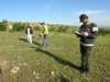
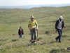
GEOSCAN RM15 resistivity meter was operated, as in previous years, by three workmen
from the village of Şahmuratlı (Fig. 41) under the supervision of the geophysical survey team.
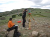
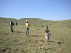
As each 20 x 20m grid was surveyed, forms were filled and a small sketch of what is visible
on the surface was drawn for each one. Where it was not possible to relocate the grid corners
set out and marked with powdered lime in previous years, the points were relocated using a
total station (Fig. 42).
Collected data was checked and processed on a daily basis so that, in the event of bad
data, equipment could be checked to ensure that it was functioning correctly while conditions
on the ground, such as standing water, could be appraised. Relevant grids could then be
resurveyed the following day on those rare occasions when such problems were encountered.
Geophysical Survey in the Southern Zone
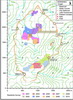
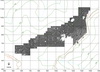
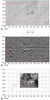
Electrical resistance survey in the southern zone was conducted in three different areas
thus enlarging the existing map (Fig. 43). Results were excellent and buildings clearly
defined.
Post-fieldwork Data Processing and Analysis
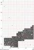
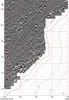
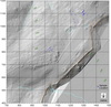
Data collected during the GPS (Global Positioning System) and geophysical survey of
the site since 1993 has been studied. Maps of the Southern Ridge include a detailed Digital
Terrain Model (Fig. 44) and geophysical images of subsurface features along the Southern
Ridge generated from the Geoscan FM36 fluxgate gradiometer and a Geoscan RM15
resistivity meter surveys (Figs 45 and 46 respectively).
Grids were combined and data processed in Geoplot so as to gain optimum clarity in the
imagery. Once basic processing of the geophysical data is done, other types of data can be
overlaid and/or combined to help with interpretation and drawing up of final plans. Further
studies and analysis is performed using Surfer and Geographical Information Systems (GIS)
software.
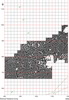
It was convenient to divide the gradiometer and electric resistance survey maps in three
sections as follows:
(i) the western end of the southern ridge (Figs 47 and 48);
(ii) the Palatial Complex and surrounding area (Figs 49 and 50);
(iii) the area between the Palatial Complex and the Cappadocia Gate (Figs 51 and 52).
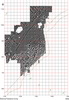
Different data sets have been used to produce a map of the Cappadocia Gate area which
includes the Stables and associated grounds (Fig. 53).
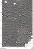
Area F, beyond the southern slopes of the Kale (Fig. 54), was surveyed with a
gradiometer in 1999 and 2000 and a resistivity meter in 2008 and 2009. In 1996, test trench
TT19 (Fig. 53) was excavated to investigate long structures partly visible on the surface of the
terraces above the Field. This trench revealed parallel walls of structures that are thought to be
'Royal Stables', as discussed below. Geophysics also revealed associated structures such as
might be expected to store bedding and fodder. The so-called Field, a flat area below these
terraces, perhaps functioned as an exercise and training ground amongst other purposes.
Area A and the sector at the western end of the southern ridge were investigated during
the 2010 spring season to determine whether there were structures similar to the distinctive
architecture of the putative 'Royal Stables' or other urban features that might have been
associated with the management of horses. The results show that there are no such structures
in either Area A or within the large urban sector towards the western end of the southern ridge
where such might have been anticipated on level ground in proximity to the Göz Baba Gate.
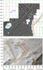
Geophysical Survey in the 'Temple' Area
At the end of the 2010 spring survey season, when there was still enough moisture in
the ground, it was possible to resume the electric resistance survey of the 'Temple' area over
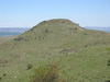
the Central Ridge (Figs 55 and 56). The large burnt two-room building on the Central Ridge
(Fig. 57) was tentatively named the 'Temple' when first revealed by the gradiometer survey.
The electric resistance survey showed up, with great clarity, the smaller structures around the
larger building.
|