|
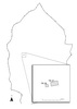
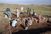
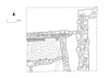
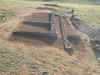
During June and the first half of July, two trenches were excavated in the south-central
portion of the city (Fig. 74). These trenches, TR27 and TR28, were positioned to uncover
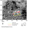
significant portions of a large two-roomed building (Structure A) and an attendant smaller
building (Structure B) revealed by the geophysical surveys in 2002, 2004 and 2010 (Figs 75
and 76). It had been suggested that the 26.5m x 12.5m Structure A might be a temple or other
public building due both to its size and its position outside of a proper urban block. It had also
been suggested from analysis of the geophysical data that Structure A had been intentionally
set on fire in the final destruction of the city. The reasons for excavating these two trenches
were therefore to confirm the reconstructed plans of these structures, to investigate their
construction and destruction, and if possible to recover material evidence related to their
functions (Figs 77, 78 and 79).
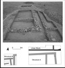
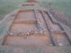
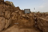
Trench TR27 was 20m in length and between 11.5m and 11m in width, exposing a total
area of 220.5m² (Fig. 80). It was situated to expose the north-eastern quarter of Structure A, a
portion of the area in front of Structure A, and a majority of the collapse from the walls of
Structure A down the slope to the north. As the rubble collapse was removed to the north of
Structure A, a portion of the southern wall and south-eastern corner of the urban block to the
north of Structure A were also revealed along with a retaining wall abutting the corner of that
urban block wall and extending to the east (Fig. 81). In the narrow area between the northern
wall of Structure A and the southern wall of the urban block evidence was found for an
unpaved street surface running along the northern side of Structure A.
The meter wide wall along the entire north side of Structure A was preserved up to four
courses of stone high and attained a maximum height of 1.4m. It was constructed, as is typical
of walls at Kerkenes Dağ, of dry-laid uncut granitic facing stones enclosing a granitic rubble
core. This wall served both as a foundation for the superstructure of Structure A and as a
terrace wall to contain the over one meter of fill used to level out the floors of the building
along the slope of the terrain. Unfortunately, significant erosion had washed away all traces of
the floors in the excavated portion of Structure A as well as any internal features such as
column bases, thresholds, or a hearth. At the north-eastern corner of the building the wall
returned a little over a meter along the front of the building. Here it abutted a less well
constructed, narrower secondary wall that was subsequently built across the opening in the
front of the building to either support a screen to block vision into the building or to stabilize
the front of the structure against erosion.
Within the structure, an internal wall was constructed to divide the ante-room (Room I)
from the main hall (Room II). Room I was originally 4.5m by 10.5m in size while Room II
was 10.5m by 19m. Complete erosion of the floor surfaces in both rooms down the northern
slope precluded any analysis of how these rooms were furnished or used. However, two lines
of stone uncovered near what was presumably the top of the fill within Room II, both of
which appeared to be parallel to the dividing wall, might be portions of substructure for
features that once sat at the original floor-level.
Outside of the structure, the enclosing wall of the urban block to the north of Structure
A was discovered under the collapse. Nothing was discovered inside the excavated portion of
the urban block other than the significant collapse from Structure A. Abutting the southeastern
corner of this urban block wall was a secondary wall running perpendicular to the
slope of the ridge. This wall was constructed as a retaining wall to minimize erosion down the
area to the east of this urban block. The area upslope from this wall, directly in front of
Structure A, was devoid of anything other than collapse from Structure A buried beneath a
layer of later erosion. No evidence for stone paving was found in front of or around the side
of the structure.
Between the northern wall of Structure A and the external face of the urban block wall a
narrow passageway 1m to 1.5m in width was uncovered. Preserved here beneath the collapse
from Structure A was a sandy layer identical to unpaved street surfaces encountered during
excavations of streets at Kerkenes Dağ in 2004 and 2008 (Fig. 82). Several micromorphology
and loose soil samples were taken from this passage and shipped for analysis at the University
of Cambridge in England as part of the ongoing project to test the results of computer
simulations of ancient traffic patterns in the city.
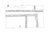
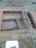
Trench TR28 was located 7.5m beyond the western edge of TR27. It was 7.5m in length
and 7m in width, exposing a total area of 52m² (Fig. 83). It was situated to expose half of the
western wall of Structure A as well as a quarter of Structure B behind it. Just as in TR27, no
floor surface or interior features were found within the narrow slot at the back of Room II in
Structure A. The west wall of Structure A was slightly wider and higher than the north wall of
the building. The increased width of the west wall of Structure A may be related to a
significant drop in the bedrock beneath the wall and in the space adjacent to it between
Structure A and Structure B. Sandy occupational material, similar to the street surface found
in TR27, was also noted running under the lowest course of the northwestern corner of
Structure A and into exterior space to the north of Structure B.
The exterior walls excavated along the north and east of Structure B are notably smaller
than those of Structure A (Fig. 84). The north wall of the building continues to run beyond the
northeastern corner of Structure B, falling just short of the west wall of Structure A. This
extension may have been built to retain fill within the half-meter drop in the underlying
bedrock just to the south of this wall, thereby preventing erosion from undercutting the west
wall of Structure A and the east wall of Structure B. A shallow foundation trench for the
eastern wall of Structure B, perhaps to provide additional stabilization, was noted along the
southern portion of this wall up to the point at which the bedrock drops considerably.
Within Structure B a single interior wall, with a meter-wide doorway at its eastern end,
divided the excavated portion of Structure B into two rooms (Rooms I and II). Burning along
the top of the dividing wall suggests horizontal beams once sat on top of this stone
foundation. Further possible evidence for the superstructure of the building was found in the
stone paving that covered the floor of Room I north of the dividing wall. The paving was laid
up to the face of the room's walls other than in a long slot-like gap along the face of the
northern wall. This slot, open to the underlying bedrock, was directly opposite four paving
stones along the southern wall face that were set slightly lower than the rest of the paving.
These stones, along with the slot and a gap in the paving at the northeastern corner of the
room may have been the bases for vertical posts used to support the roof and walls of Room I.
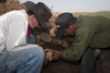
Evidence was also found for the door that once hung in the doorway between Room I and
Room II. A heavy area of ash and charcoal, along with small iron bands with nails still
attached, found on the pavement just to the north of this doorway in Room I were likely the
remains of the wooden door.
The paving found in Room I continues through the doorway between the rooms and
then extends to the south as a single walkway of paving stones into the otherwise unpaved
Room II. No evidence was found to suggest the nature of the superstructure or roof in Room
II. However, the raised walkway and a line of stones deliberately laid on top of the pavement
in the doorway, to apparently block the gap at the bottom of the door, may have functioned to
keep water, mud, or dung from entering Room I. A small nonstructural wall abutting the
dividing wall in the far southwestern corner of the trench likely delimited space within Room
II in some manner, perhaps being the edging of a bin set against the stone foundation of this
wall.
Finds
Finds from TR27
Few artifacts of note were uncovered anywhere within TR27 and none were found in
situ. This was due to the heavy erosion of all surfaces within Structure A and around it.
Portions of 5 iron nails were found scattered around TR27. These may have once been a part
of the wooden superstructure of Structure A that was destroyed in the fire. In addition, a
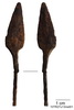
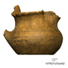
single iron arrowhead (Fig. 85) was found within the subsurface fill of Room I and a small
nearly complete painted trefoil juglet (Fig. 86) was found within the subsurface fill of Room
II. None of the artifacts provide any clues as how Structure A was used.
Finds from TR28
Room I of TR28 contained a number of artifacts in situ on the stone-paved floor. These
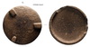
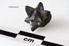
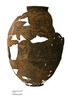
included a stone tripod-footed vessel (Fig. 87), a copper alloy arrowhead, two nearly identical
star-shaped silver objects (Fig. 88), a small tin-antimony alloy bead, fragments of iron door
bands, nails through the door bands, and several heavily broken pottery vessels (Fig. 89). In
addition, initial analysis from flotation of samples taken from the Room I floor deposit
yielded charcoal, grain, and a grape pip. No artifacts of note were uncovered elsewhere within
TR28.
Backfilling
Following the excavation and recording of both TR27 and TR28, geotextile was laid
over the tops of the exposed walls and surfaces. Both trenches were then backfilled to the
level of the modern ground surface. Each wall exposed within the excavations was also built
up to a level three courses above the modern ground surface to show visitors where the
ancient walls and structures are buried while at the same time protecting the preserved Iron
Age walls from damage (Fig. 90).
|