Aims
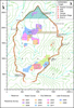
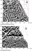
Electrical resistance survey was conducted at the northern end of the city (Fig. 34). There were two major reasons:
(i) To investigate the northern tip of the city where it was thought possible that the large building partially visible on the surface and more fully revealed through geomagnetic survey in earlier years might have had some function related to the defensive wall and the large tower at the north point;
(ii) To put into a wider urban context the large urban block (Figs 35 and 36), investigated by test excavations in 1996 and 1998, which has been selected by Dr Scott Branting, Chicago University, for a long-term program of excavation.
The whole of the northern sector was surveyed with a gradiometer in 1998, and with a resistivity meter over a small area around one of the “megarons” in 2005. Although the underlying geology obscured many of the details, this 2005 gradiometer survey revealed the presence of typical urban blocks, of the type observed over all of the city and which has come to be considered as the norm at Kerkenes. This year’s survey expanded and greatly clarified the results of previous years, furthering our understanding of the urban organisation in this portion of the city. Both structures of recognisable type and ones never observed before were detected.
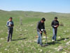
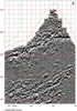
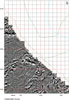
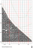
The survey concentrated on the north sector of the city, which extends from the tip of the city to the 2300m line. Exceptional conditions allowed the survey team (Fig. 37) to complete 45 days of work spread over less than eight weeks. Heavy rains and some late snow provided the adequately damp conditions for the obtainment of good images. A total of 356 grids, each measuring 20m by 20m, were surveyed with a Geoscan RM15 resistivity meter, for a combined area of 14.2 hectares (Fig. 34).
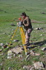
The grid established during previous survey campaigns was relocated and marked with wooden pegs and powdered lime. Where necessary, a total station was used to relocate points (Figs 38 to 41). Between four and five trained workmen from the village of Şahmuratlı operated the Geoscan RM15 resistivity meter (Fig. 42) under the supervision of the geophysical survey team. Forms were filled for each grid by archaeologists or assistants and note was taken of the features visible on the ground, be they outcrops of bedrock, wall remains or ponds.
Collected data was processed and plotted on a daily basis using the Geoplot software. This allows the odd bad grids to be identified and resurveyed in the following days. Especially damp areas were covered last. An undetected breakage in the machine resulted in poor quality data and images for some of the grids. Electrical resistance and gradiometer survey maps, together with available satellite images, balloon photography from the 1993 and 1994 seasons and GPS microtopographic survey are carefully studied (Figs 43 to 49). Final images prepared for publication are enhanced in Surfer. Preliminary plans of urban blocks and structures can be drawn by combining the different data sets (Figs 50 and 51).
Overview
1. At the northern tip it was found, as anticipated, that there was a large open area
immediately inside the acute corner formed by the city walls. This can be most clearly seen at
the top of Figure 46 where it is divided by the heavy curved line of a later animal pen. This
space would seem to be related to the road running along the inside of the defences for the
entire seven-kilometre circuit of the city wall. Such a military road would have been essential
for the efficient movement of defending forces in the event of enemy assault. An open area at
this strategic point would have obvious advantages in the mustering and rapid distribution of
defenders and of weapons. However, the substantial stone foundations of structures
immediately to the south of this open area appear to be those of an urban block of the general
type seen across much of the city. There is no reason to think, from the plan revealed by this
survey, that these walls belonged to a purpose-built military structure.
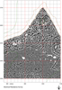
2. The urban areas inside the northwestern and northeastern sectors of the city walls are
seen to be filled with large urban blocks. While these were known from earlier magnetic
surveys and verification on the ground, as well as from test excavation conducted in 1996 and
1998, the new electrical resistivity results provide very much greater detail and clarity. This is
especially true in areas where there is moisture-retaining soil cover. There was, however, an
important and unexpected result that requires a significant re-evaluation of our understanding
of the urban infrastructure in this northern sector of the city. Where it was anticipated that the
geophysical imagery would reveal more urban blocks, each bounded by streets, as are seen
along the inside of the city walls as well as over other portions of the lower portion of the city,
there was found instead just one single "mega block" which fills much of the lower central
and left portions of the imagery on Figures 46 and 47. The buildings within this large area are
generally smaller than elsewhere and, by the time of the destruction of the city, had become
crowded. There are discernable internal boundaries forming sub-blocks, and there are
passageways or alleys, but no broad streets and no clear compound walls. Some considerable
time and effort is required, together with further verification on the ground, in order to make a
full assessment of these unexpected results and their implications.
3. The electrical resistance survey data collected sheds light on water management
within the city and possibly on ways in which this was developed over time.
|