-
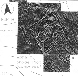
Geophysical plan of Area D2 showing the urban block, some 70 x 70m.
The two-roomed structure near the centre was digitised onto the base
map and marked on the ground. The trench was then positioned to test
the accuracy of the geomagnetic map and to provide a section through
the centre of the structure. Superficial resemblance to a “megaron”
was, as expected, totally misleading.
- Yaklaşık 70 x 70 m boyutlarındaki
kentsel yapı adasını gösteren Araştırma Alanı (D2)'ye ait jeofiziksel
plan. Orta kısımda görülen iki odalı yapı baz harita üzerinde dijitize
edilmiş ve yere işaretlenmiştir. Daha sonra açmanın yeri jeomanyetik
haritanın doğruluğunu test etmek üzere ve yapının orta kısmından bir
kesit alacak biçimde yerleştirilmiştir. "Megaron" adıyla bilinen yapılarla
olan yüzeysel benzerliğin, tahmin edildiği gibi, yanıltıcı olduğu anlaşılmıştır.