RESULTS: General
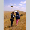
Figure 3 |
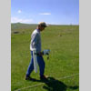
Figure 4 |
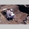
Figure 5 |
The application for a
one year AFP grant covers:
1. Photographic
and photogrammetric field studies during the summer of 2000;
2. Classification and archiving of information;
3. Addition of classified information to the data base as
a prelude to the application of analytical techniques;
4. Post-fieldwork studies, including the imaging of recorded
features and data processing;
5. Construction of virtual reality models and animations
from the combination of photographic images and scaled drawings;
6. Analysis using the GIS environment;
7. Electronic publication of the results on the Kerkenes
Project web page and as multimedia CD-Roms.
The remote sensing program,
including satellite imagery, aerial photography (aeroplane, hot
air balloon, tethered blimp, kite) together with photographic rectification
and Global Positioning System (GPS) survey, is now complete. These
particular survey methods enabled us to obtain a detailed surface
model of the site that can be combined in various ways with other
sets of data. The various methods of survey each provide digital
sets of data that display different aspects of the site. These multiple
data sets are not immediately compatible because they are each imaged
in softwares that have been specifically designed for the method
in question, and often for the particular brand of machine. Further
complications have arisen from the fact that it was necessary, as
the project evolved, to employ different projection or grid systems
in order to utilise the potential from developing technologies.
A final difficulty continues to be the unprecedented size of the
data sets, both geophysical and GPS.
In November 2000, The
Kerkenes Project was provided with a GIS package: ArcView by ESRI
including Image Analyst by ERDAS. The research team, as it is gained
knowledge of the software, has been able to solve most of the problems
that have been mentioned and results have been obtained from the
processing and interpretation of the sample data selected for the
pilot study.
During
the 2000 field season at Kerkenes, from July 3 to August 30, newly
collected data was added to that already available. Three (Figs
3 - 5) techniques were used:
(i) GPS survey with sophisticated Trimble 4600LS;
(ii) Geophysical survey with a GEOSCAN FM36 gradiometer;
(iii) Clearance and excavation.