RESULTS:
GPS survey
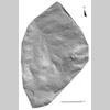
Figure 6 |
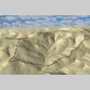
Figure 7 |
In the
summer of 2000 the GPS Survey was completed bringing the total number
of three dimensional readings obtained by kinematic survey to some
1,400,000. Total coverage of the site has made possible the creation
of detailed topographic and surface models. Balloon photographs,
geomagnetic maps, measured building plans and excavation data can
now be combined with 3D GPS data. The GPS TIN map (Fig.
6) and 3D terrain model (Fig.
7) were generated using ArcView 3D Analyst.