RESULTS: Geophysical Survey
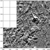
Figure 8 |
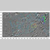
Figure 9 |
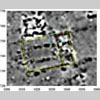
Figure 10 |
The geomagnetic mapping
of subsurface urban and architectural features with a fluxgate gradiometer
was extended to provide total coverage of about 60% of the city.
For this purpose, two GEOSCAN FM36 Fluxgate Gradiometers were used
to cover 60 hectares (60,000 square meters) in only 30 days. A sample
of geophysical image showing clearly defined structures is included
(Fig. 8);
an urban block and several two-roomed buildings can be recognised
and in some of the buildings even the position of doors can be seen.
The identification of the major urban features such as defences,
streets, blocks and water reservoirs is currently underway (Fig.
9). Combination of topography and imagery reveals in great detail
some architectural elements. The results of a test trench. TT22,
confirmed the interpretation of a columned hall (Fig.
10).