EVALUATION
Results
for this GIS pilot study, obtained through intensive effort and
dedicated application, has been good. At the larger level of urban
blocks, which has divided the northern sector of the city into closed
(=? private) and open (= public) space, the graphic data appears
to be excellent and the tabulated list of attributes is now sufficient
for the first trials with GIS analytical programs. Evaluation of
progress in the creation of a database within the blocks, and eventually
of the buildings between blocks (i.e. not within walled enclosures)
is perhaps less satisfactory because there has been insufficient
input of architectural expertise. It had been anticipated that skills
with GIS and other graphic programs do not automatically translate
into areas of city planning and architecture. The next stage is
to run analysis on the urban blocks, so as to experiment with the
huge array of ways in which the data and analysis of the data can
be portrayed in graphic form and to compare the quantified results
with heuristically derived impressions and with preconceptions that
have been subconsciously imported, to look for explanations of differences,
and to refine the attribute lists. On the more practical side, there
needs to be a re-evaluation of the methodologies involved in digitising
plans of structures, and a concomitant revision of the attribute
lists, before analysis can be run on structural plans.
The scope and aims of
this project are without parallel and will lead to the construction
of quantifiable and testable explanations of the urban dynamics
at Kerkenes. Further, the approach that is being taken offers the
potential for elucidation and explanation of the evolving dynamics
of the city over its short period of existence. One crucial element
within the research design that has been adopted is an examination
of the complex interplay between natural (e.g. topographic, water
resources, micro-climatic) influences on the one hand and cultural
choices (e.g. defences, vistas, juxtaposition of religious, administrative,
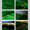
residential structures) on the other. Powerful GIS software enables
the use of detailed surface simulations, produced from GPS survey
data, for further analysis, such as topology, slope aspect mapping,
view shed analysis and communication network analysis.
Photogrammetry (Fig
30) has permitted the defences and palace glacis to be accurately
recorded. Rectification of photographs using accurately measured
points allows the wrapping of surfaces over the models for virtual
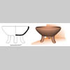
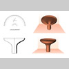
3D reconstruction. Clearance and test excavation reveals evidence
for the use of different building materials, construction techniques,
surface finishes, which may all be used in the construction of virtual
reality models (Figs 31,
32,
33). In this
respect, it is sometimes possible to clone digital photographs as
an aid in the creation of realistic simulations.