 |
| INTERIM REPORT FOR THE AFP grant 01-02-01-02, Faculty of Architecture, METU. |
|
Other Results - Hamam
|
|
Kamanli
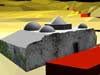
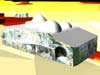
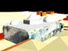
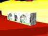
Yahsi Bey Bath in Kamanli, Urla Research Assistants: Res. Ass. Meltem Uçar and Res. Ass. Nursen Özkul; Students: Özge Basagac, F. Emrah Kösekeroglu, Yavuz S. Yilmaz, Ali Kemal Ince, Nida Nayci, IlgIn Önal, Cagdas Bora and Gül Devrim Demirel. The Kamanli Yahsi Bey Bath in Kamanli, Urla, was chosen for the design studio course, Res 506, of the Restoration Graduate Program. During the site visit, digital photographs were taken and then used to produce rectified images. Özge Basagaç used this material to pursue some post studio work that investigated further the application of rectification and 3D modeling. She prepared the following report. Report
on Rectification and 3D modelling of the Kamanli Yahsi Bey Hamam,
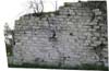
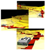
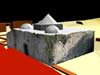
prepared by Özge Basagaç. The "hamam" and the "hamam" fountain were modeled in AutoCAD and the model imported into PhotoModeler 3. The digital photos of the elevations that were taken on site were rectified and then added to the PhotoModeler virtual model (Figs 49, 50, 51, 52 and 53). It must be noted that PhotoModeler does not handle the 3D rectification of curvilinear surfaces. Finally, the site model and the building models were combined in 3D Studio Max 4. Models allow us to reach an understanding of structural behavior of the buildings. These models can also be used to map material deterioration and structural deformations. Because PhotoModeler can display deterioration and deformations in 3D, possible causes can be deduced. Modeling can bring sites and buildings to a general public who might not be able to visit far away sites and thus enables more people to appreciate the values of cultural heritage. |
| Page Design By Alper Dincer |