Elevations
of Buildings from rectified Photographs
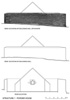
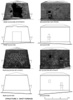
Nahide Aydin and Ízge Basagaþ have been working with different programs
to assess the potential of using photo-rectification as a reliable
method of recording buildings or other structures (Figs 34,
35,
36
and 37).
It was demonstrated that very detailed documentation of a standing
building can be made with a set of good digital photographs and limited
measurements. The rectification program used, AERIAL 5, processes
a grayscale photograph from a minimum of four known points. These
photos are then imported into an AutoCAD drawing where a simple profile
can be drawn from only a few key measurements. Details are then added
by digitizing from the image. The technique was used for the architectural
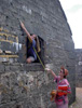
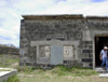
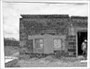
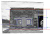
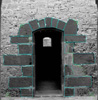
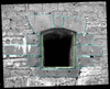
survey of standing structures at Ile de la Passe, Mauritius (Figs
38,
39,
40,
41
and 42).
The fieldwork for this research was conducted by Geoffrey and Franþoise
Summers in January 2002. Post-fieldwork processing was done at METU
with the help of postgraduate students.
The use of programs, such as AERIAL, for photo-rectification and PhotoModeler
for 3D Modeling, has shown how detailed documentation can be produced
from digital photographs. The results of such Architectural Survey
can be presented graphically in considerable detail even when time
and resources in the field are limited. The data is collected during
a short period of recording on site but intensive processing in the
office is necessary. With a limited number of measurements it is possible
to produce plans, sections and elevations of buildings. Digital recording
and the creation of virtual 3D models are also of great value in both
the study of the monuments and in the dissemination of information
on the World Wide Web. It should be noted that conservation, restoration
and future adaptation of monuments require careful planning and analysis
before any action is taken and that such techniques will assist critical
decision making.
A 3D model using PhotoModeler
This study was carried out by Ãagatay Kariptas under the supervision
of Instructor Refik Toks÷z.
There are two approaches to 3D modeling of a structure:
1. The use of images to match reference points and thus construct
a 3D model;
2. The importation of a surface model given as coordinates onto which
the images are wrapped.
In the
first method, the chosen reference points are identified on each picture
and by interpolation PhotoModeler constructs the surface model of
the structure to which the texture from the photo itself is pasted
(Fig. 43).
Photos where the structure is seen obliquely give more accurate results.
The advantage of this approach is that models can be created even
when it is not possible to measure certain points of a structure.