Other
results obtained while learning and experimenting with the programs
are thought to be of interest and are therefore reported here. They
are:
1. Drawing up of plans and elevations of stone walls using photo-rectification
techniques.
2. Planning stone pavements and producing photo-realistic images that
can be used to render both 2D images and 3D models.
3. Drawing of detailed building elevations from rectified digital
photographs and a basic AutoCAD drawing.
4. The construction of a 3D model using PhotoModeler and other modeling
programs.
Plans
and elevations of stone walls
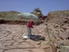
Stone walls are tedious to measure if a stone for stone drawing is
required. The time spent in the field to record all the details is
greatly reduced when using digital photography and marking control
points for rectification (Figs 23,
24,
25,
26 and
27).
Tracing from a rectified photograph can be done in the comfort of
the office (Figs 28
and 29).
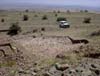
The example chosen for this study was a stretch of wall which was
revealed in a machine dug trench for water. The feature was only available
for a short time and working conditions were difficult.
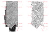
Planning stone pavements
The technique was particularly successful when used to record an extensive
area of stone pavement (Fig. 30)
that was excavated at Kerkenes in July 2002. The traditional recording
techniques involve the tedious and time consuming task of making pencil
drawing, with the help of a planning frame (usually 1m x 1m), showing
each stone at a scale of 1:20 (Fig. 31).
The technique that was developed uses digital photographs of each
1m by 1m square of pavement. The photographs were taken from the top
of a stepladder to obtain sufficient coverage (Fig. 32).
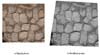
Chalk marks on the stones or nails with white and/or red tags are
used as control points for each grid square. The program Aerial 5,
which was used for rectification, produces grayscale images (Fig.
33). Work
with other software, including GIS (Arc View and ERDAS Imaging) software
is in progress and it is hoped that improved computing facilities
and programs will allow the production of photo-realistic color images
that can be used to render both 2D images and 3D models.