| |
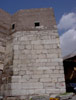
Ankara Kale
was selected for the second case study. This research, which has been
undertaken by Sinan Sülüner as part of his PhD thesis, is supervised
by Prof. Dr. Ömür Bakirer. The study focused on the towers at the Ankara
Kalesi Zindankapi where recent restoration work has been carried out
under the auspices of the Turkish Ministry of Culture.
The aim was to produce a 3D model of the towers and rectified photographs
of wall faces from which scaled elevations could be drawn. The graphics
and drawings assist in the analysis and the statistical study of the
building materials that were used and reused during construction in
the Byzantine Period.
To collect the necessary data, a GPS survey was conducted over seven
days using a Trimble 4600 LS rented from the British Institute of Archaeology
at Ankara. This GPS system utilises a base station and a roving antenna
to provide highly accurate measurements. Approximately 10,500 readings
were taken. A static survey, lasting two days, provided the UTM WGS
84 coordinates for a selection of fixed points located during the restoration
work. Points needed for the rectification were also collected using
the static survey technique while a kinematic survey provided data for
a 3D surface model.
Where it was not possible to measure points with the GPS, either because
of the inaccessibility of the point or because the GPS signals were
masked, a theodolite was used. Kemal Gülcen, from the METU Photogrammetry
Laboratory, carried out the theodolite survey, measuring (x,y,z,) coordinates
for all necessary points. Data processing was done with the GPSurvey
program. Aerial 5 was used to rectify the photographs which can then
be imported into AutoCAD as raster files. The disadvantage of Aerial
5 is that it can only handle grayscale images. More powerful programmes
are available but need a more powerful system and expertise. 3 D models
were constructed using the GIS software Arcview 3.2 and Arcview 8.2.
|
|