Photography and data
collection.
Photogrammetric recording and some photography of the Cappadocia Gate
(Figs 1 and 2)
at Kerkenes were done in 1999 and 2000. New sets of photos were taken
in July and September of 2001 according to the specifications required
for the application of PhotoModeler software for 3D modelling. A detailed
report by Instructor Refik Toksöz follows.
"Firstly,
photographic reference points (targets), comprising A5 size papers
each marked with a numbered point, were prepared. These papers were
pasted onto glacis face. In order to determine more precisely the
contours of the wall surface, more control points were placed where
the wall curved and less than were used for flat stretches of wall.
One set of photographs of the glacis was taken with an Olympus digital
camera that had a resolution of 640 x 480 pixels. A second set of
photographs was taken by Firat Ant using a Canon EOS 50 E camera loaded
with a colour negative film from which prints were made.
Transferring the images from the digital camera to a PC was straightforward,
but with the prints difficulties occurred because the automatic printing
machine cut the edge lines of the photographs haphazardly. All the
photographs had, therefore, to be reprinted with white borders so
that the original edge of each frame was precisely known, which is
needed because camera calibration is employed in referencing the control
points. The prints were then scanned and imported into PhotoModeler.
Models were produced from each of the two different series. When these
two models were checked against the control points (measured with
a Sokkia Total Station) the following results were observed: Modelling
with the digital camera was straightforward but, because of the low
resolution of the image the control points were not accurate.
Modelling with the scanned photos was easier because of their higher
resolution and the resulting model in Rhino proved to be more accurate
when checked against the surveyed control points. On the other hand,
printing and/or scanning is tedious, costly and introduces errors.
Since the first trials, a new 2048x1532 JVC digital camera has been
used. This provides very high quality digital photos from which very
good results can be achieved. The high resolution permits zooming
of the image on a computer screen and thereby allows for the precise
location of control points.
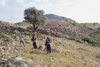
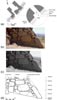
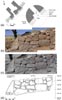
The Total
Station (Figs 7
and 8)
was used to collect the data needed for the rectification of photographs,
as well as for the precise measurement of structural elements. Accuracy
is necessary in order to match the photographs with the model, thus
creating realistic texturing of 3-D electronic simulations. Results
using this technique are summarised below (Figs 9
and 10). Wall elevations
can be also drawn from rectified photos (Figs 11,
12 and 13).