3.
METHODS
The survey was carried out using the following methods:
(1) Tethered Balloon Photography;
(2) Photography from a Hot Air Balloon;
(3) Planning;
(4) Geophysics;
(5) Field Walking;
(6) Regional Survey.
1. Tethered Balloon Photography:
A helium filled blimp (fig. 4), from which a remote controlled camera was suspended, was used to take series of
overlapping photographs of the city from altitudes of between 60 and 300 meters. Similar photographs
were also taken of a number of sites in the immediate vicinity. These included some of the many burial
mounds (mmuli) in the area, the complex at Göz Baba and a small Early Bronze Age site on the edge of
the village. Black and white, colour slide and colour print films were used and we tried one roll of infra
red film by way of experiment.
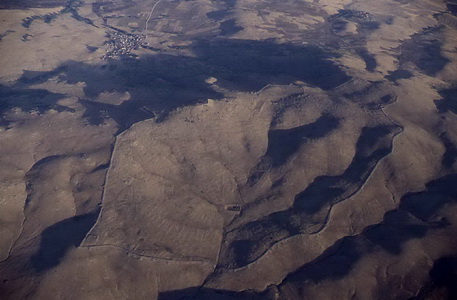
2. Photography from a Hot Air Balloon:
One problem was going to be the location of the hundreds of photographs taken from low levels with the
helium balloon (fig. 5). The solution was a flight over the site in a hot air balloon through the generosity of the
Kapadokya Robinson Lodge Balloon Team, arranged in co-operation with Prof. Wulf Schirmer. The
photographs thus obtained provide an invaluable overview of the whole site.
3. Planning:
A fairly large area at the southern end of the site, including the south gate, was of special interest because
it contains many features that are not apparent elsewhere in the city. This area was planned using a Sokkia (fig. 6 )
total station (electronic theodolite). We are now editing the data and expect to be able to produce contour
plans and three dimensional terrain models using a computer. This will be done over the coming months.
Measured drawings of some individual buildings were also made.
4. Geophysics:
A team from GEOSCAN Ltd. used a resistivity meter (fig. 7 ) and a magnetometer (fig. 8 ) over selected areas at the
southern end of the site. There were three aims: a) to test the level and usefulness of any results, b) to see
if there were buried features, especially buildings or parts of buildings, that could not be seen on the
ground or on the balloon photographs, c) to see if evidence for the function of particular areas within the
site could be found.
Initial results, produced in the field, were very encouraging. Processing of the data continues and is
scheduled for completion towards the end of March 1994.
5. Field Walking:
Most of the territory in the immediate vicinity of the ancient city was walked over and a small number of
sites were recorded. Of these only two would seem to be of any importance. (i) Göz Baba (fig. 9 ), on the highest
point of the Kerkenes Dağ comprises a large tumulus of unknown date surmounted by a later tower of the
late Roman or Byzantine era. A wide and rather crude dry stone wall embraces the tumulus and extends
down a slope to enclose a small perennial spring (the Göz Baba). (ii) Karabağ is a monument close to the
confluence of two streams c. 500 m. below and to the north of the northern most point of the ancient city.
The main structure is built of huge rough blocks of stone, up to 2.5 by 1.5 by lm.. which are almost
cyclopean. In plan the structure appears to be roughly square with engaged towers on each corner. It
would appear to be roughly contemporaneous with the city on the evidence of scant surface sherds. It was
perhaps a temple or a tomb. There is a central stone lined shaft (recently emptied) which may belong to a
secondary use as a tumulus. The monument appears to have been incorporated into a later complex,
perhaps a Selçuk caravansary with associated structures or a large konak with out-buildings.
The whole region is littered with tumuli. There is considerable variety in size, construction and date. They
are situated in a wide range of locations, high ridges, flat fields, gentle slopes and over the ruins of the
ancient city itself. The majority have been robbed, many in the very recent past. Some of these tumuli
have been photographed but the task of mapping them has not yet begun.
6. Regional Survey:
Some of the sites in the region that are shown on von der Osten's map were visited and re-recorded. A
small number of diagnostic sherds have been placed in the Yozgat Museum. Only one new site was
discovered (a small EBA mound on the edge of Şahmurath Köy) and enquiries in the neighboring villages
failed to reveal the existence of other sites. There is, however, extensive evidence of seasonal camp sites
on the higher ground. The areas to the south and east of Kerkenes Dağ have been fully surveyed, those to
the west and north remain for 1994.