|
TEST EXCAVATIONS Some of the test trenches by Erich Schmidt in 1928 were cleaned out. Trenches along the western side of the city and which appeared to be free of later levels were selected (numbers 4, 5, 6, 8, 10 and 11). By beginning in this way it was possible to obtain an understanding of the nature of the archaeological and geomorphological deposits with the minimum of disturbance. It also enabled us to familiarise the workmen with the basic requirements of excavation. We then excavated a number of new test trenches (TT15-19 following on from Schmidt’s numbering) which were each carefully sited to answer particular problems and to test hypotheses. The approach was to maximise the amount of information recovered with as little disturbance to the site as possible. Trenches were excavated in several parts of the site, all but one where geomagnetic maps had raised questions. At the end of the excavations new courses of stone were added to the wall tops with broken glass between the ancient and modem work, strips of plastic were laid along the bases and up the sides of the trenches and the earth was put back (Fig. 7). In this way, and following the precedent set at Bogazkale, the lines of the buildings are made visible while the original structures and the sides of the trenches are preserved. Aims
Results 1. Geophysical Detailed comparison of geomagnetic maps and excavated structures is continuing. It has become clear that the geomagnetic maps contain more information than we have heretofore been able to extract from them and that much is to be gained by careful comparison of geomagnetic maps and balloon photographs with features visible on the ground. Exactly what the geomagnetic maps show is now better understood, allowing for greater confidence in their interpretation; but the reasons for the strength and weakness of particular signals, the relationship between signal strength and burning, and for a constant north-south discrepancy between the position of buildings on the maps and their actual position on the ground are all matters for future research. Another area for experiment is geophysical determination of differing surface material, especially identification of stone paving and burnt clay floors. 2. Ground Penetrating Radar 3. Destruction 4. Dendrochronology 5. Micromorphology 6. Architecture Two-roomed structures, prominent on the geomagnetic maps (Fig. 8) in several areas of the site, are not “megarons”; rather, they comprise a smaller roofed unit, with wide central doorways, leading to a walled but unroofed unit (Fig. 1 Area D, TT16 & TT18; Figs 9, 10 and 11). The large complex to the north of the “Cappadocia Gate” (Fig. 1, Area A, TT 19) has the characteristic plan and paving associated with animals (Kroll, 1992) and were perhaps the imperial stables. In general, many structures had timber frames filled with mud-brick on top of stone footings, although some walls appear to have been built of stone to roof height. Internal surfaces were laid clay floors, many external surfaces were stone paved. There seems to have been a development in building methods during the short life of the city. The architectural forms are strongly reminiscent of an Eastern tradition. The construction techniques, devoid of embellishment, also echo pre-Achaemenid Iran and show no discernible influence, e.g. drafted masonry, from Lydia or Ionia (see the comments by Stronach, 1978, 10-11). 7. Objects Other objects of note include a composite object comprising a (?boars) tusk, preserved wood, copper (?alloy) sheet and pins (perhaps a cheek piece for a horse, Fig. 16), an ivory “handle” (Fig. 17), a large quantity of very well preserved iron (e.g. Fig. 18), a large piece of lead (probably an ingot) and a plain gold “strap end”. The pottery, although not prolific, mirrors that found by Schmidt in 1928. There are a few sherds with coarse white slip panels and polychrome paint, some small fine black polished bowls with flat or disc bases and a very few incised or impressed grey ware sherds. The great majority of pottery is plain, table ware being predominantly red, kitchen ware grey. There is a small repertoire of forms. The complete and closely dated ceramic corpus is distinctive. It is not yet possible to ascertain changes in the ceramics during the short life of the city. The only recognisable import is a thumb-nail sized rim sherd from what appears to be a Lyconian cup.
|
 Fig. 1 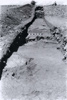 Fig. 3 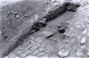 Fig. 4 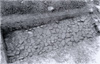
Fig. 5 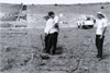 Fig. 6 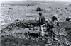 Fig. 7 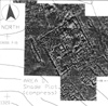 Fig. 8 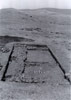 Fig. 9  Fig. 10  Fig. 11 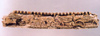 Fig. 12 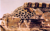 Fig. 13 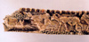 Fig. 14 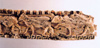 Fig. 15 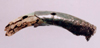 Fig. 16 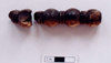 Fig. 17  Fig. 18 |