 |
AIMS
and METHODS
[ Specific aims | Global Positioning System Survey (GPS) | Geomagnetic Mapping | Total Station Mapping | Ground-Truthing | Computed Data Sets | Illustration and Cataloguing of Finds from 1998 and Previous Seasons | Test Trenches | Survey Net and Göz Baba Monument | Publication, Electronic Dissemination of Results and Permanent Archiving ] At the start of the 1998 season it was decided to concentrate all efforts on the northern third of the city because of monetary constraints and for logistical considerations. Earlier plans to spend the latter part of the season investigating aspects of the zone of public buildings at the high southern zone of the city were reluctantly given up in favour of concentrating all resources on the northern sector. Specific aims 1. Topographic
Global Positioning System survey, led by Scot Branting, of the northern
third of the city and linking with GPS survey of the Kale and its environs
carried out in 1997. 2. Geomagnetic survey of the northern portion
of the city incorporating earlier surveys in Areas B, D and F. 3.
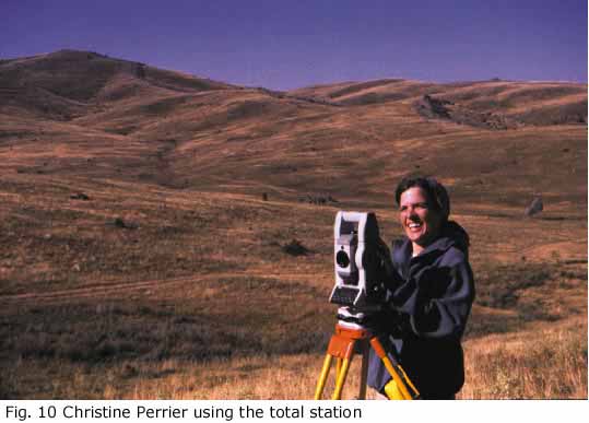
Measurement of urban blocks with a total station for combination with existing
rectified balloon photographs and digital maps produced therefrom.
All for these aims were completely or very largely achieved, the greatest deficit being in the ground truthing of geomagnetic plans because of the time needed to process and print data to a suitable scale once it has been collected. |
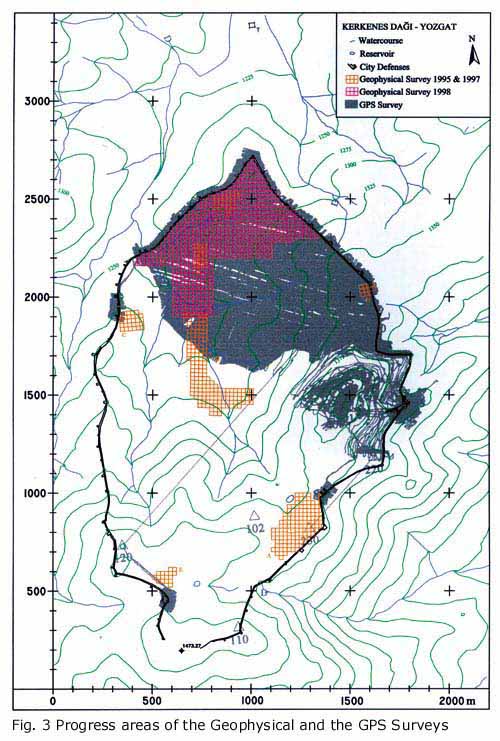 |
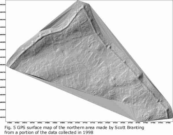
Global Positioning System Survey (GPS) A surface map has now been made of approximately one third of the entire city. 20% of which was made in 1998. In addition to the mapping of a large contiguous area, GPS maps were made of each of the seven city gates. The GPS was also used to fix points on the Kerkenes survey net at Karabas and Göz Baba. It is estimated that a further two seasons will be needed to complete the city map, depending on the availability of equipment and the extent to which the detailed topographic mapping is carried beyond the city walls. Future research design includes using GPS to map communication routes, water resources and tumuli outside the city. The images in this were made in Surfer software form a total of c. 375,000 individual readings, of which 75,000 were taken in 1997 and 300,000 in 1998. |
|
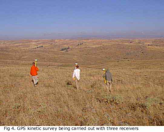
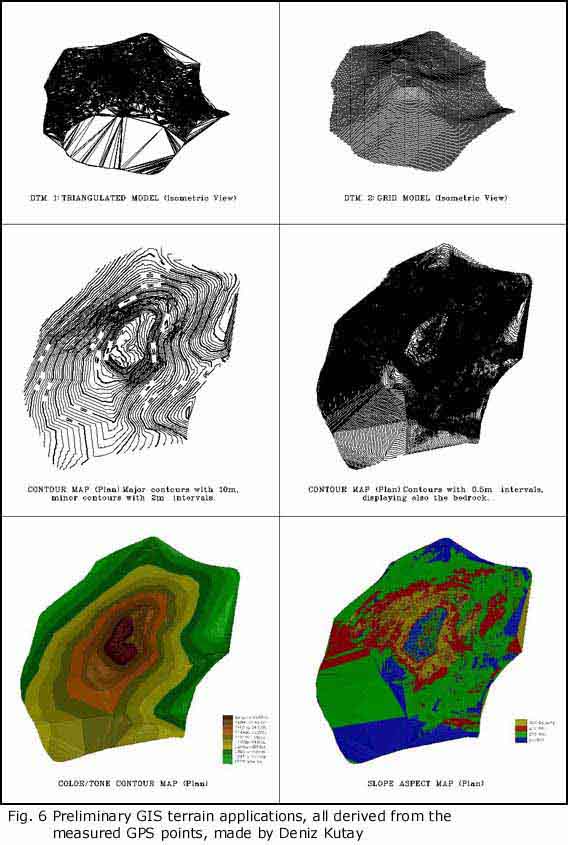
In 1998 it was possible to do much of the mapping with one base station and three roving receivers because, by good fortune, the BIAA GPS equipment is identical to that loaned from Chicago by Scott Branting. Kinematic survey is carried out by setting a base station over a known point on the survey net and walking three receivers in parallel traverses c. 1 to 1.5 m apart. Each rover is set to read every two seconds. The system operates for about six hours per day in the field, the data thus collected taking some four hours to download. Processing time is difficult to estimate, partly because experience reduces it and partly because higher levels of processing, image making and combination of different data sets has yet to be completed. Initial two-dimensional maps are produced in Surfer. Traces can be viewed and printed out as a control on the evenness and density of the data collection. Three-dimensional digital terrain models (DTMs) can be produced in a number of different programmes and displayed in different ways. AutoCAD plans and rectified balloon photographs can be draped over the terrain models and buildings reconstructed and rendered in various ways, such as by extrapolating from digital photographic images. The GPS data will also be used for Geographical Information System (GIS) analyses of various aspects of the city and its environs. |
|
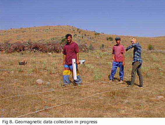
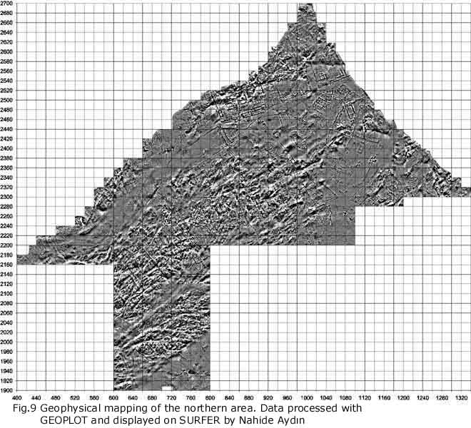
Geomagnetic Mapping Geoscan RM 36 fluxgate magnetometers were used to map an extensive area of the city at the northern end, linking up with Areas B, D and F from previous seasons. Perhaps 25% of the available area has now been surveyed in this way and it is estimated that another 3 to 4 seasons will be required to complete the geomagnetic mapping, depending on the availability of equipment and funding. The resulting maps (Figs 9 and 14) show subsurface remains in remarkable detail. Data is collected in 20 x 20 m grid squares, four readings per metre at one metre intervals, north - south / south - north zigzag. Experimentation in 1997 showed conclusively that providing the quality of data collection is high there is very little additional information to be gained from higher sampling densities at Kerkenes, although printed images might be slightly smoother. Higher sample densities entail more frequent dumping of data from the magnetometer to a lap top in the field, more processing time, processing in smaller units (because of limits on the amount of data that Geoplot can handle) and greater digital archiving capacities. The next stage, to be carried out over the coming months, is to integrate the two-dimensional magnetic data with the three-dimensional GPS data. In a future season, perhaps the spring of 1999, it would be most informative to re-map carefully selected grids with a resistivity meter to see if combination of the two methods could clarify subsurface features where magnetic signals are heavily influenced by the proximity of bed-rock and to examine the possibility that resistivity might yield information about depth and surface type. Whatever the results of such experiments, magnetic mapping will be the main method employed at Kerkenes, other remote sensing techniques being restricted to trail areas or applied to test specific hypotheses. |
 |
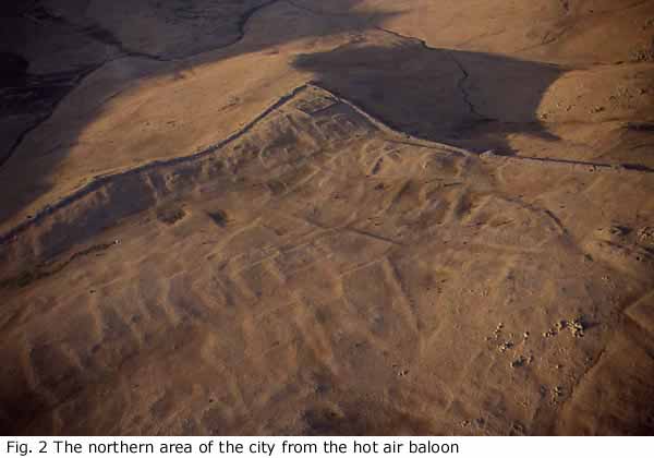
Total Station Mapping Terraces to the south-east of the area selected for geomagnetic mapping were surveyed with a total station. Across this area of the site there is much out-cropping bedrock and a number of substantial later tumuli, but the outlines of "urban blocks", streets and passages are here particularly clear. The total station plan has been combined with the urban map digitised from rectified balloon photographs to give an excellent map of the main urban features. Detailed building plans will be obtained by geomagnetic survey in a future season. |
|
Ground-Truthing Drawings made from a combination of survey techniques, especially the geomagnetics, are checked against visible surface remains. This checking allows some details to be filled in, e.g. where outcropping bedrock obscures magnetic signals or has been incorporated into structures or the identification of water courses. In some cases it allows wall widths to be measured. Post-destruction features, such as tumuli, animal pens and shepherd huts can also identified and excluded from the city plan. Much of the area surveyed during the 1998 season will require detailed ground truthing in 1999, following data processing and the production of interpretative drawings. |
|
|
Computed Data Sets Preliminary images are appended to this report. Over the coming months there will be further integration of these data sets into the GIS database. There are two distinct goals: visual presentation and urban analyses. |
|
|
Illustration and Cataloguing of Finds from 1998 and Previous Seasons All finds have been drawn, photographed and conserved, both from Kerkenes itself and from the regional survey. In addition, the expedition has made a proposal for the full restoration of a near life-size, Roman, terracotta statue of a female for the Yozgat Museum. The statue is currently in c. 250 pieces but appears to be very largely complete. It was recovered by the Yozgat Museum Director, Mr. Musa Özcan, during rescue excavations at Cemali Höyük. After completion of restoration the statue will take pride of place in the Yozgat Museum. |
|
|
Test Trenches Two test trenches were dug in 1998. Both trenches, TT 20 and TT 21, were extensions of TT 15 dug in 1996. Both trenches were positioned with the aim of recovering objects where there was actual or potential interference by villagers. TT 20 comprised the remaining two thirds of the room at the north end of TT 15 in which the ivory plaque was discovered. TT 21 was in the room at the southern end of the same urban block over an area recently dug over and which had produced fragments of bronze objects. Overall, the results were disappointing and added little to our understanding of the ancient city. A separate report has been prepared. |
|
|
Survey Net and Göz Baba Monument The net of fixed survey points drilled into bed rock was extended to include Karabas, Pürcüklü Höyük (also called Burç Höyük), the most prominent of the tumuli on the ridge to the west of the city, and the Göz Baba monument. A geomagnetic map was made at Göz Baba. |
|
 |
Publication, Electronic Dissemination of Results and Permanent Archiving Satisfactory progress has been made in the preparation of publications
and material for the Project Web Page. Fund raising for the Monograph
has also been satisfactory but further funding is being actively sought.
Major articles for imminent submission are on the Kale and other late
remains for Anatolian Studies and an overview resulting from the British
Academy Symposium on Anatolian Archaeology for an issue of the Proceedings
of the British Academy. |