 |
MAJOR RESULTS OF THE 1998 KERKENES DAG SURVEY
[ Historical
and Chronological | Defences | Urban
Dynamics | The Future ]
The results and interpretations given below are of a very preliminary
nature. There will be much refinement and addition over the coming months
as analysis progresses. Some of the tentative conclusions suggested below
lack detailed presentation of the evidence to support them, this is partially
due to the page limitations of such a report and partially because of
the further processing and presentation of the data.
Historical and Chronological
A major advance has been the suggestion, made by Professor David Stronach,
that the foundation of the city, called Pteria by Herodotus, was founded
by the Medes not following the Battle of the Eclipse (May 25, 585 BC)
and the ensuing peace treaty between the Medes and the Lydians, but
somewhat earlier as the base from which the Medes conducted the five
year war against the Lydians. This suggestion has much merit and important
implications.
Firstly, the date at which Median Empire expanded into north-central
Anatolia would be pushed back to before the time of Astyages accession
to the throne. Since the fall of Urartu is now considered by many to
have been as early as 640 BC, the major obstacle to such an advance
of Median power is removed. It would seem most unlikely, however, that
the Medes extended their power into and west of the highlands of Eastern
Anatolia before the final destruction of the Neo-Assyrian Empire in
610 BC. The date for the foundation of Pteria could thus be put back
from around 580 BC towards the very end of the seventh century.
Secondly, raising the date of the foundation provides a longer time
span in which the city could have grown. Previous estimates, c. 585
- c. 547 BC, were less than 40 years or two generations. The new estimate
might increase occupation by a generation.
Thirdly, the failure to complete the defences, i.e. not building the
mud-brick superstructure, apparently not completing the "military area"
and perhaps not completing the monument at Karabas, might all be seen
in the light of the Median-Lydian peace treaty. Indeed it seems possible,
but admittedly highly speculative, that one provision of the treaty
was cessation of further defensive construction. Fourthly, acceptance
of the higher date would necessarily imply the permanent stationing
of a considerable military force of Medes and, presumably, their allies
from which the war with Lydia was conducted. This has important implications
for the infrastructure of the city which might now be expected to have
had a far greater military component than had previously been thought.
Fifth, there are considerable and important considerations concerning
the nature of the Median-Lydian 5 year war. In particular, it no longer
becomes necessary to envisage Median forces crossing and recrossing
the Zagros Mountains each campaigning season.
Thus the higher date now proposed for the foundation of the city has
many attractions. It will doubtless be resisted by those scholars who
view the Medes as a relatively trivial force and who take a minimalist
approach to the existence of a Median Empire. It is clearly of great
importance to establish the precise date of the foundation of the city.
Dendrochronology offers the best prospect since the discovery of textual
evidence is extremely remote.
|
|
|
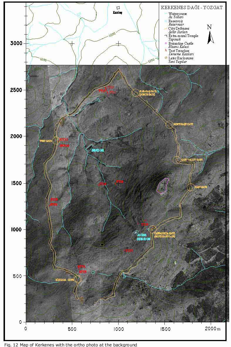
Defences
Study of the defensive system has been completed. The major addition
to our understanding of the seven gates and they in which they might
have functioned is the realisation that passages are indeed surprisingly
wide, most being around 8 m. It seems that, as at contemporaneous Lydian
Sardis and earlier Phrygian Gordion, the defensive superstructure was
not carried over the gate passages. Defenders atop the wall would thus
have had to descend and reascend the wall in getting from one side of
a gate to another. At Kerkenes, where the topography beyond the gates
often involves steep descent, it is possible that these wide gate passages
facilitated the rapid deployment and retreat of mounted troops.
|
|
Unlike Lydian Sardis,
Phrygian Gordion or Urartian defences, there is no suggestion that walls
or defences at Kerkenes were battered.
In the system of Kerkenes defences a number of influences might be
detected. The possibilities suggested below have great significance
in reaching an understanding of the cultural dynamics of the western
portion of the Median Empire. The Kale appears to have formed a steep
and barren peak that, whether or not it was walled, performed the role
of a citadel as a place of last resort once defences were breached.
This, according to A.W. Lawrence, is a Greek concept, (although it might
also be seen at Lydian Sardis). The butting of towers and buttresses
against the face of the curtain wall, rather than bonding them in, is
also western, as might be the gates discussed above. There is little
if anything in the system of defences at Kerkenes that seems to fit
into a Near Eastern tradition as seen, for instance, in Urartu, Assyria
or the Neo-Hittite cites south of the Anatolian Plateau. One site that
does offer some parallel is the Neo-Hittite centre on the Göllü Dag
(near Nigde on the Central Anatolian Plateau), but the parallel is probably
very superficial since the function of the Göllü Dag site is very different
to that of Kerkenes. The apparent western influences in the defences
at Kerkenes are in sharp contrast to the architectural forms within
the city which have clear Iranian antecedents. What is to be made of
this surprising western influence in the defences at Kerkenes? An attractive
possibility is that the incoming imperial power, having no great urban
tradition of its own, employed an architect from the West to design
a defensive city that, after all, needed to defend itself against tactics
employed by the states of Anatolia (Lydia, Cilicia and whatever lay
to the north). If this speculative suggestion has merit it, could be
seen in the light of the later, Achaemenid, use of non-Iranian expertise
and Alexander's employment of an Ionian architect to design the defences
of Alexandria.
|
|
|
Urban Dynamics
Urban Zones
In 1998 much progress was made in the definition of urban zones at the
northern end of the city. At the time of the catastrophic fire there
were large urban blocks, each with a columned hall, along the inside
of the city wall and separated from it by a street. On the two parallel
ridges south of these prestigious blocks the urban units are smaller
and the structures within them different in both character and function.
The shallow valleys have been found to contain a number of previously
unrecognised and substantial reservoirs, indicating substantially more
management and control of water resources than hitherto realised. Further
analysis of the pattern of urban zoning is a major goal of the next
few months.
|
|
Chronological Development
At the foundation of the city the line of the city wall and the position
of the seven gates were decided and the interior was centrally apportioned.
Military considerations might have of greater importance in the initial
planning than previously suggested. From the 1998 season it has become
apparent the northern tip of the city contained an open lozenge shaped
space associated with a special structural complex that differs in plan
from the blocks with columned halls on either side. The earlier contention
that there was an unfinished military road around the inside of the
city defences remains the only plausible way in which the defences could
have been intended to function. Thus, at the northern tip of the city
there seems to have been a public, probably military complex, hardly
a surprising conclusion, but one lacking proof of function.
|
|
The large blocks inside the city wall at the north end, apart from
that at the tip, each contain a columned hall oriented in the same direction,
and other structures of similar character. Test excavations in Area
B (1996 and 1998, TT 15, TT 20, TT 21) have apparently confirmed that
the urban block wall was the primary construction. It is most plausible
that the columned hall was also a primary structure. Thereafter the
blocks were filled with buildings during the brief life of the city.
The apparently haphazard positions of the lesser buildings within the
blocks under discussion was dictated by topography, level areas being
used first, later buildings requiring substantial infilling and terracing.
Chronological indicators include spatial patterning, building techniques
and materials and perhaps building forms (discussed in a separate section
below).
The areas initially enclosed by the urban blocks were above the wet
marshy areas in the broad shallow valleys. As the reservoirs were constructed,
water channels built and muddy areas paved with stone there was an encroachment
into the previously open areas, and perhaps on the military road inside
the city wall.
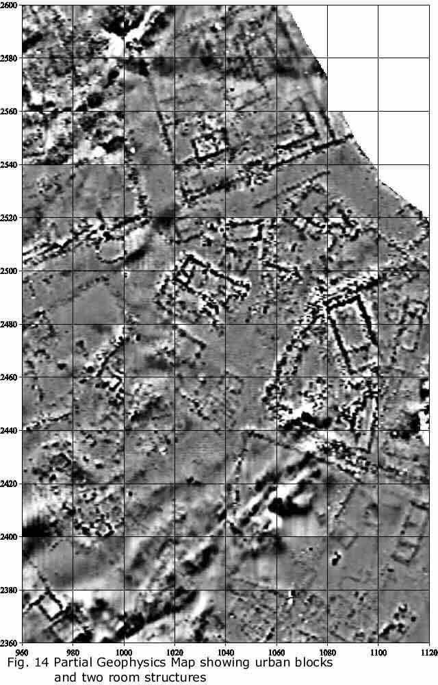
Building Typology
A typology of buildings is slowly emerging. There are a number of apparently
unique structures or building complexes which include each unit within
the public zone to the south and the large complex at the northern tip
of the city. Some building types, however, occur repeatedly, the most
obvious being columned halls, two-roomed structures, small square structures
(perhaps containing ovens) and long narrow buildings divided into small
chambers. Some building types are associated with compounds or yards,
most notably the two-roomed structures.
|
|
Urban Communications
It still seems that originally there was a broad street, no less than
5 m in width, running around the city immediately inside the city wall.
Like the wall itself, this street seems to have been left unfinished because
passage is greatly restricted in places by substantial outcrops of bed-rock.
It is self evident that such a street would have been an essential element
in the military design of a defensive system 7 km in length since it would
have enabled defending forces to rapidly reach points under attack. Open
access around the inside of the defences would also have been essential
for the practical business of construction. Encroachment onto this street
is difficult to date, but most if not all of the stone walls that can
be seen to cross it are the work of pastrolists and post date the end
of the city. The construction of substantial animal pens and shepherds
shelters in the lee of the defences continues to this day.
Other broad streets connect the city gates and also provide access
between urban blocks to the street around the wall. It is not yet known
if these streets were paved, some were certainly levelled and have retaining
walls or perhaps even steps. Narrower streets and alleys were certainly
stepped where the terrain was very steep (such as the slopes below the
Kale surveyed in 1997).
The street plan that is emerging at the northern end of the city, however,
appears to show that communication and circulation within the city was
restricted in such a way that the zone of elite urban blocks with columned
halls (if our interpretation is correct) are isolated from traffic to
and from the gates. In other words, we appear to see an urban zone that
was only provided with circuitous access to even the closest of the
city gates. It seems probable that this restriction of circulation was
not part of the original urban plan but came about as open space between
urban blocks was built over, and might thus represent a deliberate trend
towards exclusiveness and privacy. All of the above is, of course, highly
speculative and may need to be revised in the light of further geophysical
survey.
The
Future
Major Areas of Investigation
1. The military or defensive dynamics of the original urban foundation
need further elucidation. Two essential areas of future research are:
(i) a greater understanding of communication and deployment of defending
forces within the city and (ii) a better understanding of the line chosen
for the defences and the positions of the gates in relation to potential
attack and responses to attack by sorties. The first of these areas
of research will be approached, in the first instance, through further
geomagnetic and GPS mapping; the second through GIS analysis of the
defensive circuit in relation to topography and approaches to the city.
2. Changes to the urban infrastructure that took place over the 2-3
generations of city's life. Abandonment of the defences, apparently
before completion, was presumably linked to a change in the primary
function of the city from that of an imperial military base (from which
the Medes fought the Lydians and perhaps others) to an imperial city
that administered rule over subject peoples within internationally agreed
borders. The "horizontal stratigraphy" being revealed by geomagnetic
mapping will document these developments.
3. Full identification of the urban zones, determination of differences
in status and functions of zones and interaction between zones. Completion
of the mapping is clearly the first stage. Determination of function
will doubtless require further test excavations. To date, for instance,
we do not know the specific function of any of the building types that
have been identified, nor do we even have candidates for major religious
elements within the city confines, nor for industrial areas and workshops.
4. Detailed geomagnetic and GPS mapping of the southern zone of public
buildings.

 Back
to Report Index Back
to Report Index 
|