|
|
ABSTRACT
In 2002
the Kerkenes Project brought to a conclusion the remote sensing survey
in which various methods, balloon photography, close contour GPS mapping
and geomagnetic survey, have been used to reveal surface and sub-surface
remains. Coverage extends over the entire area of this exceptionally
large Iron Age capital which has thereby been revealed in remarkable
detail. Geophysical survey will continue to play a role, albeit, much
reduced in the next phase of research design at Kerkenes, but the great
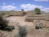
task of surface and sub-surface mapping is complete. In addition, excavations
in the Palace Complex revealed architecture of quite unexpected sophistication
while at the 'Cappadocia Gate' a section was cut across the entrance
passage and part of the stone glacis was repaired.
|
|