THE URBAN SURVEY
Completion
of the Geomagnetic Survey
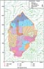
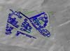
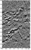
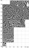
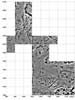
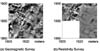
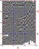
The geomagnetic survey was completed in 2002 (Fig. 9).
Since our first tentative steps we have mapped more than 2 square
kilometres using Geoscan FM 36 fluxgate gradiometers, taking four
readings per metre at one-metre traverse intervals (Fig. 11).
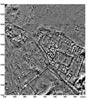
Only the Kale and the Kiremitlik, where Byzantine and other remains
obscure Iron Age structures, were omitted (Figs 17,
21,
23a,
24a,
25 and 26).
When Lewis Somers of Geoscan started us off in 1993 none of us imagined
that in our tenth season we would complete a magnetometer survey of
the entire site.
Other news includes the award of a scholarship to Nahide Aydin to
read for an MSc in geophysics and anthropology at the University of
Mississippi. Nahide has been a central pillar of the Kerkenes Project,
coordinating the survey and training local workmen. Mark Francis has
completed outstanding data processing and has also created an archive
of both the raw and processed data.
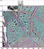
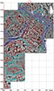
Resistivity Survey
Following the excellent 2001 results in the lower area of the city,
a large portion of a three-week spring season in May and the earlier
part of the main summer season in June was given over to extending
the resistivity survey (Fig. 10).
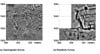
Before the soil dried out exceptional results were obtained in relatively
stone-free areas (Figs 12,
14,
18,
22,
23b
and 24b).
At a maximum of eight grids per day it would take more than 100 years
to make a complete resistivity survey, so it is perhaps no bad thing
that most of the site is unsuitable!
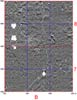
Geographic Information Systems, GIS
Scott Branting, now a graduate student at the Department of Anthropology,
SUNY Buffalo, and a member of the Kerkenes team since 1994, has become
an Associate Director of the Kerkenes Project. Scott, whose special
contributions lie in GIS and Remote Sensing, completed the close contour
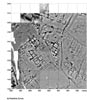
GPS survey in 2001 and has since been able to scale, mosaic and overlay
the colour slides taken from balloons in the first two seasons. He
is currently developing research into GIS applications and transport
modelling systems at Kerkenes. Nurdan Atalan, who has assisted Scott
since 1998, is now coordinating the building of the GIS database at
the METU Project Office. ESRI and ERDAS's generous provision of ArcGIS
and ERDAS Imaging enables the Kerkenes Project to remain at the leading
edge of innovative research.