Geoffrey & Françoise Summers
Kerkenes Homepreviouscontentsnext

Methodology     


click to enlarge
fig 1

click to enlarge
fig 2

click to enlarge
fig 3

click to enlarge
fig 4


Initially we aimed to create a plan of the city from blimp photographs. From the air the general aspect of the site is clear, many of the streets, urban blocks and even buildings being easily seen. Details of many buildings were visible and photographs required checking on the ground. There is, however, such a plethora of remains that location is often difficult. Collation of hundreds of blimp photographs was greatly aided by high altitude images taken during an evening flight in the Cloud 9 hot air balloon, an experience that we shall never forget. Our debt to Kaili Kidner and Lars-Erich Moore is self evident (Fig. 1). Gratitude is also due to John Haigh, University of Bradford for much help and for his photographic rectification programme AERIAL.

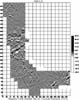
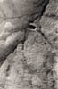
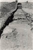
In the first season collaboration with Lewis Somers enabled successful experimentation with magnetometry and resistivity. Following completion of balloon photography, emphasis shifted to geophysics and the possibilities of making sub-surface maps of large areas, including those where no buildings are seen on the surface (Figs 2-3).

The combination of mapping from balloon photographs, geophysical survey and detailed ground observation threw out a range of questions that ultimately were only going to be answered, if at all, by precise and strictly limited excavation. Thus, in 1996 a number of test trenches were dug in collaboration with Mr Musa Özcan and his staff at the Yozgat Museum (Figs 4).


Page 4

Kerkenes Homepreviouscontentsnext