| |
THE KUŞAKLI HÖYÜK SURVEY
Stefania Mazzoni
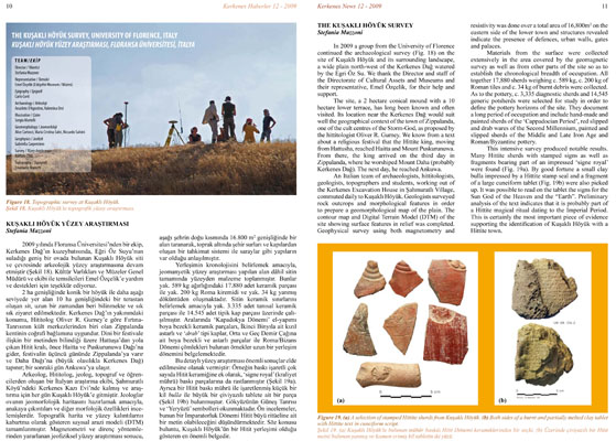
In 2009 a group from the University of Florence continued the archaeological survey (Fig. 18) on the site of Kuşaklı Höyük and its surrounding landscape, a wide plain north-west of the Kerkenes Dağ watered by the Egri Öz Su. We thank the Director and staff of the Directorate of Cultural Assets and Museums and their representative, Emel Özçelik, for their help and support.
The site, a 2 hectare conical mound with a 10 hectare lower terrace, has long been known and often visited. Its location near the Kerkenes Dağ would suit well the geographical context of the town of Zippalanda, one of the cult centres of the Storm-God, as proposed by the hittitologist Oliver R. Gurney. We know from a text about a religious festival that the Hittite king, moving from Hattusha, reached Haitta and Mount Puskurunuwa. From there, the king arrived on the third day in Zippalanda, where he worshiped Mount Daha (probably Kerkenes Dağ). The next day, he reached Ankuwa.
An Italian team of archaeologists, hittitologists, geologists, topographers and students, working out of the Kerkenes Excavation House in Şahmuratlı Village, commuted daily to Kuşaklı Höyük. Geologists surveyed rock outcrops and morphological features in order to prepare a geomorphological map of the plain. The contour map and Digital Terrain Model (DTM) of the site showing surface features in relief was completed. Geophysical survey using both magnetometry and resistivity was done over a total area of 16,800m2 on the eastern side of the lower town and structures revealed indicate the presence of defences, urban walls, gates and palaces.
Materials from the surface were collected extensively in the area covered by the geomagnetic survey as well as from other parts of the site so as to establish the chronological breadth of occupation. All together 17,880 sherds weighing c. 589 kg, c. 200 kg of Roman tiles and c. 34 kg of burnt debris were collected. As to the pottery, c. 3,335 diagnostic sherds and 14,545 generic potsherds were selected for study in order to define the pottery horizons of the site. They document a long period of occupation and include hand-made and painted sherds of the 'Cappadocian Period', red slipped and drab wares of the Second Millennium, painted and slipped sherds of the Middle and Late Iron Age and Roman/Byzantine pottery.
This intensive survey produced notable results. Many Hittite sherds with stamped signs as well as fragments bearing part of an impressed 'signe royal' were found (Fig. 19a). By good fortune a small clay bulla impressed by a Hittite stamp seal and a fragment of a large cuneiform tablet (Fig. 19b) were also picked up. It was possible to read on the tablet the signs for the Sun God of the Heaven and the "Earth". Preliminary analysis of the text indicates that it is probably part of a Hittite magical ritual dating to the Imperial Period. This is certainly the most important piece of evidence supporting the identification of Kuşaklı Höyük with a Hittite town.
|