
City Plans
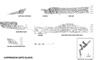
Photogrammetric elevation of the 'Cappadocia Gate'. The glacis is preserved to its full original height in the niche.
Click to Enlarge
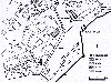
Map of the southern area of the city showing the location of the monuments partially cleared in 1999.
Click to Enlarge
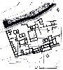
Plan of an urban block in Area B. Structures have been planned from a combination of balloon photography, surface mapping, geomagnetic survey and the test trench.
Click to Enlarge