Kerkenes Home Up << Page 6 >> Index


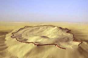
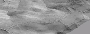
GPS Topographic Survey:
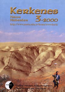
In 1997 Scott Branting initiated a highly sophisticated Global Positioning System (GPS) survey. In 2000, assisted by Nurdan Atalan and Köksal Sanli, Branting completed this essential component of the remote sensing program at Kerkenes. The result is based on some 1,400,000 individual readings obtained through intensive kinematic survey with 4600LS GPS Trimble equipment. Most of the survey was conducted using one base station and three roving receivers. The collected points, with an accuracy of ±10-20cm, have been processed to form the basis for the terrain model that was produced using ArcView 3D Analyst software.  
(See: Scott Branting and Geoffrey D. Summers, 'Modelling Terrain: The Global Positioning System (GPS) Survey at Kerkenes Dag, Turkey.' Antiquity 76, 2002.)


3D Modelling:

The 3D data allows the creation of virtual fly overs and animation. This is the first time that such intensive GPS survey has been carried out over an entire ancient city, underscoring the central role that the application of new, non-intrusive, techniques play in the development of research design at Kerkenes. Technologies with archaeological potential advance rapidly. It is worth noting that such highly accurate GPS did not exist when the Project was inaugurated in 1993.


3D Views:
Selected areas can be studied and close up views can be produced, viewpoints and angles can be changed. One draw back however is the need to continuously upgrade the project's computer stock to avoid maddening frustration caused by hours of processing time and frequent 'locking up' of machines or 'Illegal Operations' and such...


Setting up the Base Station:
Let us however go back to field techniques, perhaps less frustrating but no less demanding in term of logistics and problem solving. One receiver was always set up as a base station. It was very fortunate that in 1998 and 1999 Scott was able to bring with him the University of Chicago Trimble set which matched that of the BIAA. Thus, when both sets were available, three 'rovers' collected data at the same time.


Three Roving Receivers:

The 'rovers' were carried by team members or local workmen walking systematic transects two meters apart as data readings were taken every two seconds. The density of data was increased if necessary, e.g. where remains and significant features were recognisable. Daily walking averaged 6 hours with only one short breakfast pause. The afternoon was spent downloading the data.


Kerkenes Home Up << Page 6 >> Index