|
SURVEY OF SITES IN THE IMMEDIATE VICINITY
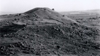
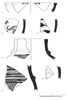
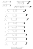
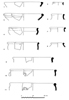
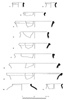
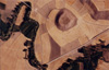
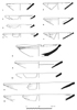
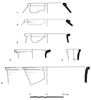
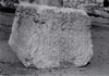
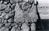
It is indeed fortunate that we are able to collaborate closely on many aspects of the surveys. The primary aim of the Kerkenes Project survey is to try and locate contemporaneous settlement, and particularly sites which might fit the testimony of Hero dotus who tells us that Croesus enslaved the inhabitants of Pteria and chased away the inhabitants of the surrounding villages. A secondary aim is the examine the occupation and land use of the region through time, both because it is an interesting and worthwhile study in itself and because we hope to be able to answer questions relating to traditional land use and deforestation. The survey is intense and involves walking much of the area as well as obtaining local information in the villages. Only a small area remains to be walked in 1995, preferably after autumn ploughing. General Observations Sorgun was formerly Buyuk Köhne and sometime Yeşilova. The Eğriöz Su was sometime the Yeşilova Su. The mounds to the west of Sorgun are all on the south bank of the Eğriöz Su and receive fresh water flowing northwards from the granitic massif of Kerkenes Dag or coming from the numerous perennial springs in the area. There is no such regular fresh water on the northern side of the river. The proximity of mounds to one another in this region, in sharp contrast to areas east and west, presumably reflects the water bearing granitic bed rock. It may be assumed that water was more abundant before the deforestation of Kerkenes Dat. The date of the deforestation is an outstanding problem. Sites with Glacis Three such sites have been visited, Keykavus Kale, Gözbaba Tumulus and Tilkigedigi Tepe. A fourth is known at Sümerin Sivrihisar. There are two, related, problems: the date and the function. Based on the 1993 observations it was thought that the glacis at Keykavus Kale ran up to, and was therefore contemporaneous with, the mortared castle wall. Evidence recovered from Tilkigediği Tepe (Fig. 18) and Tilkigedigi Tepe Tower in 1994 suggests that the glacis is Iron Age and the mortared Byzantine tower was without any such additional defensive device. The site of Tilkigedigi Tepe appears, from the evidence provided by recent digging for treasure which has exposed the stratigraphy, to be of a single period. The pottery (Figs 19, 20, 21, 22) is of Achaememd (Persian Empire) date. This throws open the date and function of Gözbaba Tumulus, if it was ever a tumulus, and the date of the glacis on Keykavus Kale. There is clearly a system of watch towers and beacons and it may be that this is Iron Age in origin although the pottery shows that it is later than the Iron Age city on the Kerkenes Dat. It must then, by a process of elimination, belong to some part of the period of the Achaemenid Empire. The Hittite Empire Period Due north of Kerkenes Dag and visible from it, at the confluence of the Egrioz Su and the Kötü Dere, is the large multi-period site of Ku~akh. It has long been known that this was a major urban site in the period of the Hittite Empire (second half of the Second Millennium B.C.) and that it was also of considerable importance in earlier and later periods. The site is also of general interest because its position in a shallow, broad and well watered valley bottom parallels the position of Alişar Hoyuk (compare Figs 23 and 29). The blimp photographs clearly show the different elements of the site and its setting. The high central mound is uncultivated because of the steepness of the slopes and appears brown from the dead vegetation at the end of the summer. The more or less oval lower town is seen in the field boundaries; it has been clipped by the modem village road at one end and stone-work belonging top a Hittite city gate can be seen on the curve of the wall just above the balloon tether rope. The pottery (Figs 24 and 25) came from a trench dug for the planting of saplings along the line of the wall exactly where the tether rope crosses it in the photograph. It was also clear that the wall was destroyed by fire from the mass of highly burnt mud-brick in the farmers trench. In the Roman period the site was more extensive but this does not show well~, perhaps photographs taken in the spring, with differential crop growth, would provide additional information, but the line of the late mortared wall (? Roman) around the top of the central mound stands out at this time of year. The meandering pattern of the Kötü Dere, lined by trees, suggests that, as at A1işar, the earliest levels of occupation at Kuşaklı lied buried beneath many meters of silt and alluvium. Other Sites in the Kerkenes Dag Survey Area The other sites are listed and briefly described in the gazetteer (Appendix 1). The aims of the survey are set out elsewhere in this report and some of the preliminary results are discussed under the relevant sections. The ambition is to document the pattern of land use and settlement in all periods as efficiently as possible. The quantity of material collected is kept to the minimum necessary to determine the dates of occupation (as far as is possible) at any given site. The two sites described above are exceptional in that recent exposure provided rare opportunities to gather groups of material that clearly came from a single context and are thus worthy of publication in their own right. On the other hand, precise written records are kept of the areas covered by the survey, the modern land use, ground cover at the time of the visit and so forth; and notes on all pottery seen on the surface are made at the site before a small representative selected as evidence or for further study. The survey covers all periods and Figs 26 and 27 show evidence of high and late Byzantine spolia recorded in two villages.
|
Fig. 18
Fig.21
Fig.22
Fig. 23
Fig. 24
Fig. 25
Fig. 26
Fig. 27
Fig. 29
|
|||||||||||||