|
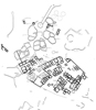
THE BYZANTINE VILLAGE ON THE KIREMITLIK The Kiremitlik, the place where there is pottery, is situated at the southernmost area of the Iron Age city on the Kerkenes Dağ which is also the highest part of that ancient site (c. 1,472m. above sea level according to the 1:25,000 map). It affords a magnificent view over the undulating plain to the south and southwest. It is presumed, on the basis of the recent pattern of land use and older remains, that at the period we are most concerned with here, the Late Roman and Byzantine, the inhabitants of this small site exploited the area of the ancient city and the slopes outside for orchards and vineyards as well as grazing sheep, cattle and horses. Some of the field and animal enclosures in the vicinity were contemporary with the periods of settlement, in particular the east facing slopes below the Kiremitlik and inside the line of the earlier city wall. Occupation was probably seasonal because the winters on this high and exposed position are long and bitterly cold. The later periods of settlement on the Kiremitlik smother the Iron Age city wall. History of Exploration In 1927 Erich Schmidt sank two of his fourteen test trenches on the Kerkenes Dağ in the Kireniitlik (Schmidt 1928: site 1 and 2, and passim) in order to obtain a sequence of occupation. The trenches were designed to reveal the earliest occupation in this area of the site and to ascertain the date of the city wall. In 1993 photographs of the area were taken using a helium filled blimp. It is these photographs, together with observation and measurement on the ground that form the basis for the present report. The Sequence of Occupation The sequence of occupation was established by Schmidt and the present authors have seen nothing amongst the prolific quantity of pottery sherds on the surface to modify Schmidt’s conclusion that occupation extended from at least as early as the Hellenistic (Schmidt’s “Greek”) period until early Byzantine times. The Earlier city wall was apparently constructed in the mid-first millennium B.C. Settlement may not have been continuous from the Late Hellenistic period until final abandonment but only fiuther excavation could establish the detailed sequence. The periods of occupation are approximately the same as those on the Kale but the exact nature of the relationship between these two sites has not been established. The area has subsequently been used, as it still is today, for seasonal grazing and shelters for both animals and shepherds obscure some of the more substantial earlier remains here as elsewhere within the Iron Age city. Location The site commands a fine view to south and southwest and would have given the residents ample warning of danger from these directions, e.g. of Arab raids across the Cappadocian Plain, and its relative isolation would in itself have given protection. The site was well chosen for multi-resource seasonal occupation, grazing, gardens and perhaps hay-making. Being on the highest and most exposed part of the earlier site it is subject to the strong winds that blow almost every day in the summer. There is water available from springs, although these are not bountiful today, and wells. The granitic bed-rock that comprises the whole of the Kerkenes Dag protrudes from the modem ground surface at almost the highest point on the Kiremitlik,demonstrating the obvious point that the topography of the site, with sudden and marked differences in level, reflects the underlying geology. Aims and Methods The aim of this part of the Kerkenes Dağ project is to record and interpret the remains visible on the ground at the Kiremitlik. The focus is on the latest Byzantine settlement which can be seen almost in its entirety and thus affords an excellent opportunity to examine a small rural and probably seasonal settlement of the Early Byzantine period in Northern Cappadocia. From the photographs and observations on the ground it has also been possible to discern something of the development of the site from a rectilinear settlement into a less regular group of complexes that, nevertheless, display some unity and general conformity. Neither the precise dates nor the span of time involved in this development of the site can be documented from the surface remains although the prolific surface pottery is no later than Early Byzantine. The blimp photographs display a palimpsest of remains. The drawing is an interpretation of the latest phase of settlement. No attempt has been made to correct for photographic distortion because a combination of observation on the ground and the level of guess work involved in drawing the exact position of the walls suggests that rectification would impose a false level of accuracy on the end result. Description The site straddles and obscures the Iron Age city wall although both of the vertical faces of have been utilized in places and can still be seen (Fig. 17) It appears from the distribution of surface sherds that occupation extended beyond the city wail in the Hellenistic period. What is more certain is that the Byzantine settlement was undefended as can clearly be seen on the western and southern sides. There are two types of building plan visible on the surface, regular rectilinear complexes of Early Byzantine date (solid black on Fig. 17) and later curvilinear structures (hatched on Fig. 17) which often modify the earlier buildings. There is an ancient track to the site from the south which, according to Schmidt’s observations, was once paved. There are further tracks to the northeast and north that are still used today. The track to the west, leading towards Gözbaba with branches off the southern plain and northern slopes, and which can clearly be seen breaching the walls, is a relatively recent drove road which is still in use. From the remains still visible in Schmidt’s Site 2 and from his published description it is clear the buildings of early Byzantine date (Schmidt’s Roman) were, like most of the recently built houses in the villages on the plain below, built entirely of stone with, to judge from the almost total absence of roof tile, timber and earth roofs. An abundance of building stone and the lack of silt or clay on the Kerkenes Dag and the veiy sandy nature of the soil in the plains below explains the preference for stone over mud-brick. All the visible structures are built of dry stone walling, in contrast to the Byzantine defenses on the Kale which are constructed of rubble and lime mortar. Since there is no calcareous stone in the vicinity the absence of mortar is not surprising but it does demonstrate that roofs were not vaulted. All the stone is local granite, there is no cut stone on the site. Nevertheless, walls were well and neatly constructed with the face stones carefully fitted together, in contrast with later and temporary shelters in the immediate area. Generally the walls comprise two faces with a few stones placed in gaps between. They are approximately a consistent 0.80m. in width. The buildings have been divided into complexes. What is visible represents the final stage of a lengthy period of settlement during which the site expanded and underwent some modifications. The growth and alterations are, for the most part, obscure. Conclusions The Early Byzantine site on the Kiremitlik represents a village, perhaps seasonally occupied in the spring and summer with the main settlement somewhere in the plain to the south. There are no defenses. In its final form it represents the modification of a similar Late Roman or Byzantine village. The nature of earlier Roman and Hellenistic occupation beneath the extant remains has not been elucidated. The single story buildings were constructed entirely of dry stone with traditional timber and mud roofs. The plan displays some recognizable order with groups of rooms around courtyards or open areas. The economy was presumably based on grazing with some viticulture and orchards and, in the fields below, cereals. There is evidence of pottery manufacture on the site. Although the site is fairly small, the quality and quantity of fine red slipped pottery and glass suggests some degree of wealth, considerable above the level of subsistence.
|
Fig. 17
|
|||||||||||||