ASSOCIATED EXTRAMURAL
SITES
1. The Monumental Temple
at Karabaş
Extramural temples and shrines have a long and widespread
ancestry in the ancient Near East. Close to home is the great Imperial
shrine of Yazihkaya at the Hittite capital of Hattusa and numerous
references in second millennium Hittite texts to festivals and shrines
in the countryside. Closer in time, in Mesopotamia, is the famous
New Year Festival Temple at Babylon and the less well know extra mural
temple at the Assyrian ceremonial capital Assur. Nearer still are
the out-door shrines (but not temples) of Urartu. In ancient Persia
too religious monuments are found beyond the walls. It is thus no
surprise to find a monumental stone temple outside the city at Kerkenes
Dağ. Its monumentality and good state of preservation, however, is
a welcome bonus.
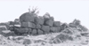
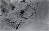
The survey of Karabaş began in 1993 with balloon photographs, photography
of the standing remains and brief notes. Further photographs were
taken in 1994 (Figs 14
and 15).
The full significance and character of the structure only became fully
apparent dining the detailed investigations carried out in 1994. The
remains comprise two structures of apparently different dates. This
report focuses on the monumental Iron Age building, full description
of the later complex being left for the final publication when it
will be possible to place it in a wider context.
Methodology
Weeds, but not perennial shrubs, were cleared at the start of the
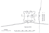
1994 investigations. The final plan will be drawn from a combination
of ground survey using a total station and blimp photographs (Figs
15 and 16).
Profiles were measured with the total station. Well preserved wall
faces were drawn at a scale of 1:20.
Position
The monument is situated on a slight natural
rise some 680rn. due north of the northernmost corner of the ancient
city on the Kerkenes Dağ adjacent to a poor spring (dry in late July
1994), close to the confluence of Kale Dere and seasonal stream flowing
from the east. The monument stands on or close to the road from the
north to the gate in the north-east city wall and immediately west
of the modern track from Babalı to Gözbaba Köy. It does not have a
conimanding view and therefore is unlikely to have served a defensive
or military function. There are much better places to build a military
tower a little further to the north or on the surrounding hills.
Date
The monument is contemporaneous with the Iron Age city for the following
reasons. Firstly is its striking position in relation to the northernmost
point of the city, locally known as Burch (meaning tower). There is
no discernible reason to have chosen the particular location other
than the relationship to the northern tip of the city because the
prospect is poor in every direction and the spring, even if more copious
in the past than today, is meager in comparison to many others in
the vicinity. Secondly, the building techniques are the same as those
used in the city walls in two important respects, the use of large,
uncut granite blocks with smaller stones filling gaps and the strange
way in which the outer buttressed skin of the building is built against
the outer face of the building echoes the abutment of the towers against
the outer face of the city wall.
Function
Temple for the following reasons:
(1) the position, outside city, is a traditional Near Eastern position
for seasonal festivals;
(2) massive construction is indicative of
an important public building;
(3) walls are aligned to the cardinal points;
(4) a military function can be discounted because of(a) the location,
(b) the small size which would have been insufficient for a gamson
of any numerical strength and (c) the architectural concept.
If it is a Median temple it would presumably have been a fire temple.
Other possibilities are few: were it to have been dedicated to local
gods it would imply that the location had some long-standing cultic
importance for which there is not a shred of evidence. From what we
know of Median religious practice at Harran, which may not apply here
of course, there is no precedent for their respect of local cults.
An alternative might be a royal tomb or at least a temple associated
with royal burial.
Description
The building is monumental in concept and execution with wall faces
aligned with the cardinal points of the compass (Fig 16).
It appears to have been a freestanding tower built entirely of stone.
The plan is approximately a square with corner buttresses and some
internal division. There are two parts to the structure, an inner
building and an outer skin with buttresses constructed against the
outer face of the inner building. Details of the plan and elevations
are problematic and both the position and the nature of the entrance
is unknown. it is possible that the structure was originally within
an enclosure or teminos or that there were associated terraces on
one or more sides. Later adaptation and disturbance has, however,
obscured the original setting.
Construction Techniques
All walls are built from blocks of uncut granite with small stones
tucked into the larger interstices (Figs 14
and 15).
The inner building was presumably erected first since it would otherwise
have been necessary to move stones into the existing rectangle of
the outer skin. It is possible that the two parts of the building
were constructed together with the outer skin built up in stages to
facilitate raising stone to the upper parts of the inner wall, but
in this case it is difficult to explain why there were two separate
walls. it is more probable that the outer skin was added to enhance
aesthetically rather than support the inner structure. There is no
reason to assume that the inner core was in physical need of support
because the construction technique used for the city defenses displays
the same features of abutment and addition, although the necessity
for structural support remains a possibility. The buttresses on the
corners of the outer wall or skin are bonded with it. All visible
wall junctions in the inner building are bonded.
Plan
The plan is approximately square with corner buttresses (Fig 16).
All the walls appear to have a standard width of c. 1.75m. Since the
external walls were built faces to face the total thickness is c.
3.50m. The internal plan is impossible to determine and there are
various ways of reconstructing it from the extant remains, none of
which are without problems. The difficulties stem in part from later
reuse and more recent disturbance from treasure seekers.
The Entrance
The position of the original entrance is no longer discernible (without
excavation). If there was a door at ground level it would seem that
the only possible position was at the south side where the walls are
ruinous. If entry was by way of a stairway that was integral with
the outer skin it might have been on the south or the north side,
and if on the latter may still be extant beneath the present talus.
An external stairway butted against the outer face could be reconstructed
in any position.
The Chamber
The stone chamber confuses rather than clarifies any reconstruction
of the building. It would seem certainly to have been part of the
original structure because the two visible corners, at the north end,
are bonded. The possibilities are:
(1) a casemate or foundation for a high and solid platform which would
have been above the highest part of the structuxe that has survived,
in this instance other casemates would have been at 90 degrees, as
evidenced by the exposed inner face of the north wall;
(2) a grave within a funerary temple of grandiose tomb (or just possible
belonging to a later tumulus) in which case it appears to be awkwardly
long, thin and deep;
(3) a hollow shaft within the core of a platform for drainage or ritual;
(4) an internal stairway or passage.
If it was a passage or long narrow room it is difficult to see how
the western side of the building functioned without windows and it
seems more probable that this side of the structure was a platform.
The key question is whether the floor level is below the base of the
chamber or was above the existing remains.
The East Side of the Structure
The eastern side of the structure appears to comprise four units,
two rectangular chambers to either side with two roughly square compartments,
narrower than the flanldng chambers, in the center. The chambers measure
c. 5.00 by 1 lm. so that it would have needed timber beams in excess
of 5.25m. to have roofed them; substantial but not impossibly so.
On the other hand, they might possibly have been voids and the axial
square compartments the base of a raised area or support for stairs
from the east. If the building faced east the eastern most central
compartment may have been the focus or the foundation of the focal
room.
2. Gözbaba
Reference has been made above
to the monuments at Gozbaba on the highest part of the Kerkenes Dağ.
The monuments were recorded in 1993, but the apparent association
with the “ceremonial” street and direct access from the
northernmost of the two western city gates give cause for further
comment. The monument was recorded by E.F. Schmidt and H.H. von der
Osten. There are five visible elements:
(1) a large tumulus like heap which resembles other large tumuli in
the vicinity;
(2) a stone pavement covering the slopes of the tumulus like monument;
(3) stone foundations of a tower like structure on top of the monument
and apparently, but not absolutely certainly, associated with the
building on top;
(4) a cold perennial, if weak, spring just below and to the south
of the monument;
(5) a massive, low, very crude, dry-stone enclosure wall that embraces
the spring and adjoins the sides of the main monument.
On the basis of scant surface sherds it was suggested at the end of
the 1993 season that the mound was a tumulus (following the original
publication, and that the other features were of Byzantine date. The
possibility exists, however, that the nature and date of the various
elements needs to be re-evaluated and that the mound either is or
encases a religious or ceremonial monument contemporaneous with the
Iron Age city. It will be suggested below that the stone pavement
and perhaps the tower might belong to the Persian period, in which
case they would have been constructed on an earlier, Iron Age monument
whatever its exact nature. We hope that geophysical survey will again
provide an answer to this enigmatic problem.
3. Water Reservoirs
Water at Kerkenes Dağ in 1994
There was very little winter snow and spring rain on the Anatolian
plateau in 1993-94. There was a week of rain just before Kurban Bayrami
and it was then dry until a couple of exceptional haW days in late
July and early August. When we arrived the Büyük Göl was dry and the
Sülük Göl a muddy puddle. On the 4th of August the Sülük Göl dried
leaving a mass of tadpoles and leeches to their fate in the sun. Only
at the west edge where the source flows in is there some little water.
The main çeşmeler on the site have some water, that by the SE corner
and the one at Karabaş are dry. The main stream that flows through
the west wall is no longer running although the pools at the wall
contain water. In Şahmuratlı there is less water than usual in the
çeşme by the mosque, other ceşmeler are as good as dry.
Water Catchment
The west wall and cistern
Where the stream flows through the west wall there is an elaborate
series of stone lined cistern both inside and outside the wail and
the wall itself displays unique features.
City Wall
There is no gate at this point and the continuous line of the city
wall is clearly evident. The outer side of the city wall has large
rectangular towers either side of the stream. Neither the towers nor
the outer face of the stretch of wall between them appears to have
had a glacis. This is the only section of the city wall without the
glacis so far discovered. The inner face of the wall, however, has
a glacis along the equivalent section. Where the wall crosses the
stream the outer face stones are particularly large. The stream itself
presumably flowed through an outlet built into the wall. The exceptional
construction of the wall at this point was presumably a response to
the weakness created by the exit of the stream which made the wall
vulnerable to sapping at this point where it would have been impossible
to satisfactorily cany the glacis over the stream. By building a glacis
on the inside some added protection was provided. it is not surprising
that there was not a gate at this point because the weakness created
by a combination of stream and gate would have been considerable.
Inner Cistern
The inner cistern is stone built and appears to have had a corbelled
roof that has since collapsed. The mechanism by which the flow of
excess water through the wall was controlled is no longer extant.
Outer Cistern
Immediately outside the wall the stream has been modified into a large,
rectangular, stone lined, open cistern. This cistern might have afforded
extra protection as well as retaining water for animals grazing outside
the city wall.
NE Reservoir
Outside the city wall at the NE corner, at the head of the valley
that runs down towards Şahmuratlı, where there is now a group of çeşme
and immediately north of the road, a semicircular dam with a central
sluice can be seen.
Reservoirs to the West of the
City
In the side valleys that run into the Kale Dere from the bills to
the west there is a group of reservoirs the largest of which has a
dam constructed of parallel stone walls with a clay fills. It is possible
that the sides were stone lined, but nothing is now visible. These,
and others in adjacent valleys, should be visible on the hot air balloon
photographs taken in 1993; some can be seen as green patches on the
cover photograph. There is a further group of three reservoirs above
Karapmar (Gözbaba) which have largely silted up. There are surely
more in the intervening valley, which has yet to be visited.
4. Tumuli
It has become apparent that the
hundreds of tumuli in the region span several periods and are of several
different types. There are a large number within the city which were
constructed on the ruins of the deserted city, on the remains of both
buildings and defenses and which therefore postdate the desertion
of the city. None of the tumuli in the region appear to belong to
the traditions of Phrygia, i.e. they do not have timber burial chambers.
The tumuli in the region will be the subject of a special study for
an International Conference on Phrygian and Thracian relations.