THE SITE
The Setting
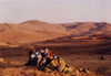
The site is situated on a granitic
mountain (alt. c. l,400m.) at the northwestern edge of the Cappadocian
plain (Fig.
1). It dominates the east-west trunk road that today links Iran
with Europe and is close to one of the natural routes linking the
Black Sea with the Mediterranean; it thus lies on a natural cross
roads close to the center of modern Turkey. The city wall was skillfully
set out around the rim of the eroded granitic dome in such a way as
to take optimal advantage of the terrain (Front Cover). The dimensions
of the city are approximately 2.5 by 1.5 km. and the length of the
city wall is some 7 km., making it the largest known pre-Hellenistic
site in Anatolia so far discovered. Most remarkably, the whole of
the interior of the city would seem to have been utilized for buildings
of various sorts with only the steepest slopes apparently avoided.
This intensity of building is the more surprising since it is clear
that the life of the city was very short, perhaps less than a generation,
and that large parts, including the very massive defensive system,
were never completed. The sheer size and urban complexity, however,
is not necessarily indicative of a huge, permanent, urban population,
and the understanding of these problems remain central goals to the
project. A further area of interest, and one that cannot be divorced
from the urban structure and the internal functioning of the city,
is the economic base that supported, or was intended to support, the
city population; and in order to address these problems intense study
of the immediate environs and consideration of the wider historical
and geographic setting is necessary.
The Historical Background
The date of the site is clearly
somewhere in the late pre-Hellenistic Iron Age, the period that goes
under the obscure archaeological name of Alişar V (a term derived
from the fifth level up from the bottom of the near-by site of Alişar
Hoyuk that was excavated by E.F. Schmidt and 11.11. von der Osten
in the 1920’s and 30’s). It is now clear, both on the
basis of the pottery that was recovered by Schmidt from a number of
the small test trenches that he dug within the site in 1928 (Schmidt
1929) and for wider reasons of historical geography and architectural
history, that the site in fact pre-dates the western extension of
the Persian or Achaemenid Empire, ultimately as far as the Aegean,
by Cyrus the Great in or a few years after 547 B.C. Further, the ceramics
are not of the (earlier) Alişar lV period which is presumably to be
dated to the eighth century B.C. By a process of elimination, therefore,
the city on the Kerkenes Dağ has to have been constructed and deserted
in the seventh or sixth centuries B.C. In view of the magnitude and
strength of the site it might be considered legitimate to assume that
somewhere in the scant records of the ancients some reference to the
city might be found. If this line of reasoning is accepted and followed,
there is only one candidate, the city of Pteria mentioned by the “Father
of History”, the Greek historian Herodotus.
The background is fascinating. After the
destruction of the Assyrian Empire by the Babylonians and Medes, acting
in uneasy alliance, a territorial division of interests was agreed
upon. The Babylonians got Mesopotamia and the Medes got the area to
the north, including of course Anatolia. The nature of the early Median
state, indeed the very existence of a Median “Empire”
has been vigorously questioned (e.g. Sancisi-Weerdenburg 1988; Brown
1990) but there is written testimony (indisputably correct, whatever
the problems that lie concealed in the scanty details and the reconciliation
of western and eastern sources) that the Medes fought a war for five
(or six) years with the Lydians and that this war, or perhaps more
properly a series of annual campaigns, took place in Central Anatolia.
The war came to an end on the afternoon of May 28, 585 B.C., a date
known to both ancient Greeks and modern astronomers since it was an
eclipse of the sun that frightened both sides to the extent that peace
was declared and a peace treaty between the two protagonists brokered
by the King of Cilicia and (or on behalf of) the King of Babylon (see
Huxley 1965 for evidence that there may have been subsequent hostilities).
The treaty fixed the ancient Halys river (mod. Kizilirmak) as the
border between the warring parties and the treaty was sealed by the
marriage of the Median King Astyages to the Lydian princess Aryenes,
daughter of Alyattes and sister of Croesus. There is thus a high probability
that the city on the Kerkenes Dağ was constructed shortly after the
conclusion of this peace treaty as the western Royal City of the newly
expanded Median Empire. Indeed, it is not impossible to imagine that
the palace was designed for the newly wed royal couple. The references
to Pteria in the histories of Herodotus (1.76) describe later events.
Astyages is overthrown in a palace revolt at the heart of the Iranian
Empire and Cyrus the Great becomes the first of the Achaememd kings.
Croesus, by now King of Lydia and gaining fame as the richest man
in the world, sought to flex his imperial muscles on the grounds,
doubtless convenient, that Cyrus had been responsible for the murder
of his brother-in-law Astyages. Envoys were sent to the most reliable
oracles of the time and, in due course, the answer came back: if Croesus
were to cross the Halys river an empire would be destroyed. It was,
naturally, just what Croesus wanted to hear and after the crops had
been harvested he led his army northeastwards, crossed the river and
sacked Pteria. According to Herodotus, Pteria lay on a line south
of Sinop and was the strongest place in that part of Cappadocia, a
geographical description that fits exceptionally well with the remains
on Kerkenes Dağ. Croesus, Herodotus goes on to relate, enslaved the
population of Pteria and chased away the inhabitants of the surrounding
villages. Cyrus the Great rose to the threat and marched rapidly from
the east. The two empires fought an inconclusive battle on the plain
outside Pteria as a result of which Croesus withdrew to his capital
at Sardis to await additional forces from his international allies
before, as he naturally thought, the renewal of hostilities in the
spring. Cyrus, however, was a man of action and rather than return
home or winter on the Anatolian Plateau he led his forces speedily
against Sardis with the inevitable result. The traditional date is
547 B.C., although there is some evidence that it may have been a
few years later (Beaulieu 1989: 80-82; Burstein 1984; Cargill 1977).
But whatever the exact year, the historical picture fits the observed
evidence at Kerkenes so closely that it falls little short of proof
the geographical location, the strength of the fortifications, the
Imperial nature of the newly founded city, perhaps (a subject of ongoing
study) eastern influences in the domestic architecture and in the
plans of the temple and palace, the short period of occupation followed
by total abandonment and the date of the pottery are consistent with
the identification. Moreover, there is no alternative historical context
that we know of in which the site might fall (although other suggestions
have been posited from time to time).
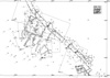
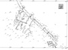
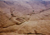
Methods of survey
The 1994 season was largely devoted
to finishing all essential balloon photography. As before, grid crosses
and control points were marked on the ground with white lime and plotted
with a total station. In some areas data was also collected for the
production of contour plans and digital terrain models. Levent Topaktaş
and his team in METU have the results in LandCAD and AutoCAD and are
combining them with plans digitized from photographs over the winter.
The overall grid was subdivided into blocks each defined by a coordinate
(e.g. A.2). Each block is then enlarged and the positions of the photographs
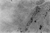
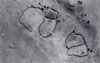
and the digitized plans produced from them are plotted. Figures 5
and 6
are working examples and some corresponding photographs are presented
in Figures 3,
4
and 5.
The Defensive System
The defensive system is constructed
from uncut granitic bedrock. The nature of the stone is such that
it often gives the superficial impression of having been shaped because
the stone has a tendency to cleave along flat planes. The wall itself
is some 4.5 to 5m. wide at the top. Built against the outer face of
the wall, at places where the lie of the ground made additional protection
desirable, have been added rectangular towers, buttresses and, in
at least two places, larger and more amorphous additions. The whole
has then been encased in a stone glacis that slopes at an angle of
around 60° and runs up so that it is flush with the top of the
wall (not to the base). Despite the great width of the wall, the number
and size of the towers, the skill of the military architect and the
labor involved in construction, the outer sloping face does not provide
much of a deterrent to a determined aggressor since many stretches
are little more than two meters in height. it is therefore thought
that the original scheme envisaged a huge mud-brick wall (as is usual
at Near Eastern sites), but that only the stone base or footing was
ever built.
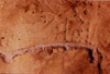
The original city gates can be
seen and seven have so far been identified with certainty; perhaps
the original total since the wall can be clearly seen for most of
its length, although later breeches (Figs 3,
4, 5,
6, 7)
may obscure small gates or openings. Each gate was individually planned
so that it provided the strongest possible defense in its particular
situation (in contrast, e.g. to Hittite gates which seem always to
follow a standard plan). Special and complex provisions against attack
were made where the stream flows through the west wall: perhaps the
Persian entrance of Babylon by means of the river outlet was an old
Iranian trick?
It is specially noteworthy that
there is no inner system of defenses, nothing to separate off a royal
quarter, no citadel or acropolis; and that there was never any intention
of constructing internal barriers is clear from the layout of the
city as a whole (see below). It is thus evident that no strife was
expected within the city itself, a conclusion that has important implications
relating to the loyalties, civil and political cohesion and ethnicity
of the inhabitants. This apparent unity is reinforced by the striking
conceptual conformity of the enclosures and buildings within the city
(described below).
No outworks or extramural defenses
have been recognized, perhaps not surprisingly given the unfinished
state of the city wall. It is quite possible, however, that watchtowers
lie obscured beneath later remains on surrounding hilltops.
The Urban Space
The use of space and the structure
of the urban fabric is becoming clearer as work progresses, both in
the field and with the photographs taken from the blimp in 1993 and
1994. This photographic coverage is now complete and comprises vertical
or near vertical shots from a range of altitudes between 60 and l,000m.,
both black and white and colour and all with considerable overlaps
and numerous ground control points. In 1994 a new innovation for the
project was oblique photography from the blimp; this was done by adjusting
the camera sling so that the camera itself was at an angle of 45°
(Fig. 10).
Different areas of the city can now be discerned and clues as to function
are becoming apparent. It is also clear from simple observation that
certain complexes were located in particular places for very specific
reasons or, in other words, there was an overall city plan and the
planner(s) had good reasons for the placing of any particular complex.
It is not perhaps overstating the case to suggest that what we are
able to see is a colonial, Imperial foundation, built as a visible
symbol of the new Imperial power, as a sign not only of wealth and
strength but also of domination. Thus, in a sense, the site is an
“ideal city”. The concepts that lay behind the planning
are thus of the greatest interest, both in themselves and for any
influence that there might (or might not) have been on later Achaemenid
and Hellenistic ideas on cities. The problem of where the influences
might have come from, fascinating and intriguing as it is, must await
renewed research to the east of Turkey since it is already obvious
that the city on Kerkenes Dağ owes nothing to Hittite or to Neo-Hittite
tradition, nor to any civilization that was native to the Anatolian
Plateau.
Since the difficult task of producing a plan of the entire city is
not going to be achieved for at least another twelve months from the
time of writing, it is perhaps premature to try and describe the whole
city. What follows, therefore, are a selection of rather disjointed
observations that are deliberately intended to display, on the one
hand, some of what we already know, and on the other, to emphasize
the potential that the project still has to offer.
To begin, as it were, from the outside, the position and the functions
of the city gates are a logical starting point. Not only (as above)
is each gate designed to maximize the defensive potential of its own
particular position, but each gate leads to and from specific places
and the places from which they provide entry to the city is reflected
by the type and function of the urban areas and individual building
in proximity to each gate. Perhaps the most important of the gates
is the southern one. The plan of the gateway itself reflects the importance,
having an internal passage and chamber with towers at the innermost
limit. The position affords a magnificent view southwards over the
northern part of Cappadocia and snow capped peak of Erciyes Dağ (Fig.
1) can be seen rising above the haze on a clear morning. A broad
and gentle road winds gently up from the plain and passes through
the gate to the most important area of the city. Immediately inside
the cities most important streets cross. One major main branch of
the road makes its way downwards along the steep side of the “kale”
and joins the northeast gate, another important street runs from the
east gate towards the great stone facade of the palace. Opposite the
south gate is an area of large terraces and long narrow structures
the function of which is currently enigmatic, it seems likely that
they were only built to foundation level (unless they were robbed
in Byzantine times) and it is possible that this was a complex of
storage magazines situated, as might be expected, just inside the
“Cappadocian Gate” through which the agricultural products
of the plain and caravans coming from the Mediterranean would have
passed. Opposite the gate, just a little to the left, is the At Göl
or Sülük Göl, the latter name being derived from its population of
medicinal leeches which have given it some local notoriety and which
attract the sick from considerable distances. Today a frog filled
pond, it was an artificial, stone lined reservoir or settling pool
at the head of an elaborate and centrally organized system of water
control and distribution.
To the left (west) gate is a large enclosed space which extends from
the east-west street to the city wall and stretches from the gate
to the corner of the palace. The western limit of this enclosure,
dictated by a sharp drop in the level of the bedrock, comprises a
long narrow (c. 3 m.), corridor like building. The function is unknown
but stables, storage or barracks are possibilities and we expect the
geophysical survey might provide an answer. On a raised outcrop of
rock that physically pervades the enclosed area is a major building
and between it and the city wall a rectangular reservoir. One other
rectangular building is clearly visible but otherwise the area was
empty, an observation confirmed by geophysical survey in 1993. The
whole of this enclosed complex, immediately inside the gate and flanking
the approach to the palace had some very special and important function
that has yet to be determined: it is possible that it was the military
headquarters, perhaps with barracks and/or stables for the Median
cavahy, exercise yards and parade grounds, but this intriguing possibility
has yet to demonstrated.
Turning left inside the south
gate, joining the street from the east gate and passing between the
enclosure and the Sülük Göl just described, would take the visitor
(ancient and modern) to the imposing monumental entrance to the Palace
(Front Cover). The situation is ideal because the roof would have
provided a view over much of the city and there was sufficient flat
terrain for construction on a scale commensurate with the importance
of the building. Few alternatives were available to the planners,
it would have been possible to build it further to the west but this
area was prescribed for different purposes and, in any case, would
have neither afforded the view over the city nor, of greater importance,
have provided a setting which maximized the imposing grandeur that
was the symbolic function of the palace. Today the most imposing area
of the city is that Kale (castle), known as Keykavus Kale after a
Seljuk sultan of that name, which dominates the mountain from the
modem trunk road to the north and which overshadows many areas of
the city (Front
Cover, Fig. 1). From Hellenistic times (if not Persian) this small
rocky outcrop was fortified and occupied. There is no evidence of
the role it played within the Iron Age city but the general layout
of the city tends the skirt the rock outcrop on all sides and there
is no hint that later Kale was of any significance in earlier times.
Indeed it is clear that the secular and religious monuments of the
Iron Age city lay elsewhere and the bare granite fingers had not yet
been adapted for occupation. In 1993 it was ascertained the palace
was destroyed by fire.
The east gate leads up from the village of Şahmuratlı, where the expedition
has its base, by most gentle route. Modern tracks carved out with
bulldozers have obliterated parts of the original route and changed
the aspect of the eastern approach. Travelers from the east would
have approached this way and have followed the street past the south
gate to the palatial area described above or have turned northwards
at the crossroads inside the south gate and made their way down town.
In moments of high fancy this gate is nicknamed the “Hamadan”
or “Ectabana” Gate.
The gate on the northeastern side would have received traffic from
the north and west which doubtless came via the large mound at Kuşaklı
(described later in this report). It also gave access to and from
the extramural temple at Karabaş (also described in a separate section
below). This gate gave direct access to the main residential area
of the city and the main thoroughfare ran, as described above, to
the southern gate.
A small gate in the western wall led to pasturage and to the groups
of artificial reservoirs in the valleys to the west that were discovered
in 1994 and are described below. Further to the south is a heavily
fortified gateway with complex outworks, much altered by later tumuli
and shepherds shelters (Fig.
13), through which the road to the prominent “tumulus”
at Gözbaba, the highest part of the Kerkenes Dağ, clearly led.
This gate, in spite of the strength of the fortifications, does not
obviously connect with major routes from further afield, courtyards
or open areas and small pools to collect rain water. Some of these
structures appear not to have risen above foundation level, an observation
that geophysical survey should be able to confirm. These large compounds,
it is surmised, were or were intended to be aristocratic residences.
To the south a grid like system of streets gives access to a second
row of similar enclosures and structure before the ground falls steeply
away to the south. The street to the south of the palace has a slight
kink, associated with a pool for the collection of water.
Turning again to the major areas of the city, the palace is flanked
by narrow streets with large enclosures on either side (Fig.
12). Each enclosure contains a major structure or structures with
then broadens out to a width of some 18m. At this point it is aligned
east-west and at the western end opens into a square or plaza with
a large rectangular building on the western side built just inside
the line of the city wall. Contrary to expectations, the gate is not
at the end of this street but a little to the north. It is, in fact,
the gate that leads to Gözbaba. It is tempting to interpret this
wide street as having had some ceremonial function because of its
obvious alignment with the rising and setting sun, and with the palace
and the “tumulus” at Gözbaba. In 1993 it was established
that there was extensive and intense burning associated with structures
at the end of the wide street. Later tumuli, constructed on the ruins
of the Iron Age buildings, have superficially changed the appearance
of the complex relationship between the street, gate, buildings and
enclosures, but the blimp photographs (Figs 12
and 13)
taken in 1994 clearly show the unity and the overall layout of these
features. Further geophysical prospection in this area of the city
is a priority for 1995.
The task of planning and understanding the rest of the city plan is
in hand and description here would be premature. One preliminary observation
that can be made relates to architecture: there is no known parallel
for any of the architectural features observed, not the city walls,
the palace, the “ceremonial” street or the enclosures
with their spacious buildings, and there is nothing that appears to
belong to an Anatolian tradition (although it has to be admitted that
we know almost nothing of the Anatolian tradition in the late seventh
and sixth centuries B.C. on the Plateau). Many of the enclosures and
buildings can be easily seen on the photographs and surface observation
has shown that many buildings, perhaps all of those that were finished
and roofed, were destroyed by fire and that there was considerable
use of mud-brick for internal (but not external ?) walls. There is,
therefore, great potential for high resolution magnetic survey of
these structures which will greatly aid interpretation.
There are a number of outstanding problems
which future study will address: the nature and function of the different
type of enclosures and buildings; the extent to which open areas within
the enclosures were used, if at all, for flocks and herds and what
other activities did the populace engage in (industrial, agricultural,
domestic etc.). It will be possible, when the city plan is complete,
to estimate the area of roofed residential structures and to use this
estimate to calculate the likely population of the city. ft is already
apparent, however, that space was plentiful and that although there
are no large areas that were not utilized the density of population
may have been far less than in other ancient cities of similar size.
Understanding of the urban framework is dependent on a number of difficult
questions of a general nature. It is imperative to discover whether
or not the city was fully inhabited all the year round or whether
it was in some sense a summer city, perhaps the base for annual military
campaigns, the collection of tribute or tax, control of seasonal international
caravan trade and so forth. An Iranian tradition of annual migration
and seasonal campaign could be postulated and it should be possible
to prove or disprove the hypothesis by determining the function of
the various areas of the city through a combination of geophysical
prospection, coring and, perhaps in 1996, a very limited number of
carefully placed test trenches. The function of the city crucial to
an understanding, and the impression gained so far is that of an imperial
foundation that was intended as a strategic military and administrative
base rather than as a self-sustaining city economically dependent
on the productivity of the surrounding countryside. This attractive
suggestion also needs to be clearly demonstrated and a program of
research is being initiated to examine the agricultural potential
of the surrounding area and to attempt to reconstruct, as far as is
possible, the ancient landscape (forest cover, pasture, arable land
and gardens). Modem mechanized farming has lead to the tilling of
much marginal land so that superficial impressions of agricultural
production must be discounted.