MAJOR RESULTS
1. Historical
It has been argued that the city was ancient Pteria, latest
observations provide further conformation.
2. Geophysical
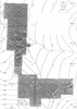
Geophysical maps confirmed a number of hypothesis and yielded
unexpected results:
3. City Plan
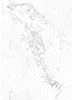
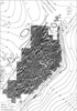
Plans of a large portion of the southern end of the city
and other areas were produced in AutoCAD (Fig. 3 and 6). It
is now possible to understand concepts that underlay the city
planning and make a provisional attempt at dividing the city
into functional zones: military, public, religious and residential.
The importance and sophistication of both communications and
water management within the city are more fully comprehended.
The inter-regional importance of the city is better understood
and its potential as a considerable military base has become
clearer. Production of population estimates is a goal for the winter,
but it is clear that the population was modest in relation to
the size of the city, a few thousand at most. Nevertheless,
there were no large empty spaces within the city.
4. Temples
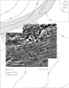
The extra mural temple at Karabas was fully recorded and
its plan elucidated (Figs 16, 17, 19 and 20). The smaller temple
within the city has also been fully studied (Fig. 18). A
report on both is being prepared for publication.
5. Later Monuments
The walls of the Byzantine castle and of an earlier phase,
perhaps Achaemenid in origin, have been planned (Fig. 21), as
has the small church complex (Fig. 22) at the castle foot. This
completes study of later monuments within the city limits. Publication
is in preparation.
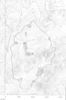
6. Regional Survey
The Regional Survey, c. Skins radius, was completed in 1995.
Preliminary conclusions are summarised below.
No neolithic or early chalcolithic
occupation was observed on the high ground of the Kerkenes
Dag, perhaps because it was then forested. Coring at Kusakli
Hoyuk in the Esri Oz valley, 4km north of Kerkenes, demonstrates
that early sites lie beneath later alluvium in the valley bottoms
(as at Alisar Hoyuk, H.H. von der Osten Alishar III). It is
postulated that neolithic and early chalcolithic lies obscured
below later occupation and geomorphological deposits in the
region. Geomorphological landscape change may be related to
highland exploitation, concomitant deforestation and erosion. We
may be able to demonstrate a shift from small seasonal late chalcolithic
sites to larger “urban” sites and permanent villages in
Early Bronze II.
Small late chalcolithic or EB
I sites are found on higher ground, many in very exposed positions.
Models for this pattern of land use are being developed while
the question of seasonality remains an outstanding problem.
Later EBA sites are fewer and
in less exposed positions, perhaps representing the establishment
of settled villages with large and modest sites in river valleys.
Second Millennium occupation
is restricted to valleys, late Imperial Hittite being found
only at Kusakli, identified with ancient Zippalanda (Prof.
O.R. Gurney Anatolian Studies XLV: 69-71; Dr. R.L. Gorny in
press). The Kerkenes peak is probably the Hittite sacred Mount
Daha, the later Kale presumably masks Hittite remains.
The Achaemenid period Kale was
fortified with a stone glacis below strong walls. Small sites
exist on surrounding peaks representing a sophisticated late
Achaemenid system of control and administration centred on
Kerkenes.