
APPENDIX 1
REPORTS ON SELECTED ASPECTS
OF THE 1997 SURVEY
Geoffrey Summers
1. THE NORTH-EAST OR SINOP
GATE
During the survey of the city defences
in 1997 a new gate was discovered at the eastern end of the north-east
section of city wall, immediately north-west of the sharp eastern turn
(Fig. 10). The gate was previously
unrecognised because, like other gates at Kerkenes, the large face stones
of the passage walls had fallen into and blocked the passage itself
Later and modern reuse of the gate has entailed the clearance of paths
and tractor tracks over the towers and city wall either side of the
passage, and the dumping of more stone into the passage itself.
The gate is at the north-eastern end of the major street that runs from
the southern, "Cappadocia Gate". The size and strength of the North-East
Gate are an indication of its importance. The route out from the gate
leads directly northwards and traces of a road may be extant in along
the hillside before vanishing into the Sahmurath Koy vineyards. Beyond
the gate is a square or rectangular enclosure that appears to be contemporaneous
with the city. There may also have been a spring immediately outside
the gate, now obliterated by the modern village road.
The plan of the gate is simple. An Sm wide passage is flanked by two
rectangular towers projecting out from the face of the city wall. The
southern tower also projects about lm inside the line of the inner face
of the city wall. Neither tower is an exact rectangle, both measure
around 6.40 by 10.00m. The northern tower and stretch of city wall stand
much higher than the southern, reflecting the underlying outcrops of
bed-rock over and around which the gate was constructed. The sections
of the city wall either side of the gate do not quite line up, which
was compensated for by the interior projection of the southern tower.
The outer face of the city wall and the towers are, as everywhere, enveloped
by a stone rampart faced with uncut granite slabs. The line of the gate
passage continues through the glacis, an architectural device which
was not used, for instance, on the west gate where the glacis clearly
continues around three sides of both towers. If the passage was 8m wide
for the whole length it would seem unlikely that the city wall could
have been carried over it, thus it can be postulated that part of the
passage was restricted. There is no evidence for the position or number
of doors.
2. THE WATER GATE
The Water Gate planned in detail
(Fig. 11). There is now considerable
doubt that the extraordinary elaboration of the defences at this weak
point do in fact represent a gate. If a passage did exist it would have
been on the east side of the stream where there is not sufficient space
to permit more than foot traffic to pass through. The stream, which
flowed through a corbelled stone structure within the city wall, debouched
into a large stone walled reservoir immediately beyond the wall. The
form of the towers that flank the reservoir appear to be peculiar to
this section of the defences. The external stone glacis, not shown on
Fig. 11, appears not to have extended
between the towers and was compensated for by the construction of a
glacis inside. Schmidt though that there was a gate here and in 1928
dug a test trench against the south-east corner of the internal glacis
in the hope of uncovering a sculptured lion.
3. THE WEST GATE
Detailed planning of the West Gate
(Fig. 12) revealed that the stone
glacis extended around three sides of the gate towers but not, apparently,
along the sides of the gate passage. This represents a different architectural
solution to the problem of joining a sloping façade to vertical
elements of the gate structure to that seen in the North-East gate (Fig.
10). Presumably the passage was somehow
narrowed in order to carry the superstructure over the top, and there
were presumably jambs for gates, but the mass of rubble that has collapsed
into the passage has obscured these architectural details.
4. OTHER GATES
Plans of the other 5 gates have
been drawn up for publication. The "Cappadocia Gate" is shown on Figs
7 and 8,
a stone plan of the East Gate is too large for convenient inclusion
here. The "Goz Baba Gate", South-West Gate and North Gate are so obscured
by rubble and later modification by tumuli and shepherds constructions
that it has only been possible to draw block plans which have not been
included here for want of space.
5. THE PUBLIC ZONE
The high southern zone of the city,
along the ridge between the "GOz Baba Gate" and the terraces on the
north-western slopes below the Kale (Figs 5,
6, 7,
8 and 9)
display an integrated concept of urban design and city planning on a
scale commensurate with the ambitious foundation, layout and construction
of the city. The descriptions that follow are based on a combination
of ground survey and observation, interpretation of balloon photographs
and geomagnetic mapping of sub-surface features. There has necessarily
been a considerable degree of interpretation in deciding what to include
and exclude from the plans and in deciding how much can be reconstructed
with a reasonable degree of confidence. Field records contain more information
and a greater differentiation between levels of confidence than limitations
of space and graphics allow here. Both recording in the field and, to
a greater extent, drawing of the current plans, have been consciously
and unconsciously influenced by our understanding of what the extant
remains represent, and by the need to present results that are coherent
and intelligible. Research is still in progress: geomagnetic maps will
add considerable clarity and detail, test trenches will provide evidence
for function and additional architectural information. Thus the results
presented here are interim and will require much expansion and some
modification as the project moves into its next phase. On the other
hand, it is thought that they will not require substantial revision
and that the broad interpretation is essentially correct, however slight
the evidence on which it is based.
The Suluklu Gol
Description
The Suluklu Gol, Leech Pond, is an artificial stone-lined reservoir
also known as the At Gol, Horse Pond (Summers eta!. 1996, 216 &
n. 23). It lies within a larger walled compound into which geophysical
survey and ground observation have not yet revealed an entrance. The
pool itself is rectilinear, measuring c. 32 by 56m Probing with a hand
auger in 1993 established that it contains about 1 .OOm of silt, making
the total original depth some 3m with a total capacity of c.5376m3.
Today it is fed by a spring to the south-west, much altered in recent
times and consequently now normally dry by the end of August. The location
of the original spring is uncertain and may well have been within the
pool itself which has a naturally sandy bottom. Doubtless recent modification
has lowered the water table and it can safely be assumed that with proper
management there was sufficient water available to keep the pool full
throughout a normal summer. It is also likely that other sources of
water, including run-off from surrounding complexes to the east, south
and west, helped to maintain the water level and some features seen
on the geophysical map running obtusely across the street to the south
channelled rain water into it.
The pool would seem to have been created by enlarging and squaring off
a natural feature and construction of a dam with a central sluice on
the northern side and the north-eastern and north-western corners. The
dam comprises two parallel walls, presumably with water impervious clay
between them, and a large bank that both supported the walls and reduced
seepage. The other three sides have vertical walls and there is a sloping
face of uncut granite around all four sides, constructed in the same
manner as the glacis around the city defences and the façade
of the "Palace Complex". There is no evidence of steps or ramps down
into the pool, but such might have existed.
Interpretation
The position of the enclosure and the pool is such that it would seem
to have formed a focal feature for the public complexes to the east,
south and north. If this is indeed the case it implies a concept of
planning and use of urban space on an imperial scale. Since the original
height of the enclosure walls has not yet been established, it is not
possible to assess how visible or secluded the pool would have been.
Construction was evidently lavish since the much larger BUyuk Gol, in
the centre of the lower part of the city, and other artificial reservoirs
elsewhere in the urban confines, were not stone lined. Clearly, the
Suluklu Gol was something more than a utilitarian reservoir. Beyond
that simple observation it would be imprudent to venture.
The "Palace Complex"
Location
The complex occupies a gently sloping area on the high ridge towards
the southern end of the city, some 280m west of the southern or "Cappadocia
Gate" and is more or less orientated east—west. The approach to
what appears on the geomagnetic map to have been a spacious open area
in front of the monumental façade seems to have been via a broad
street leading from the street node inside the "Cappadocia Gate". On
approaching the palace complex the street divides to run along each
of the long sides, that on the north eventually broadening out into
a plaza-like public space before veering off south-westwards to the
"Goz Baba Gate".
The south-eastern end of the complex thus afforded a view over the stone-lined
pool and the public buildings beyond. From elevated points within the
complex the northern Cappadocian plain could have been observed with,
on clear days, Mount Erciyes in the far distance.
Somewhere close to the complex façade was the perennial spring
that fed, and still feeds, the stone-lined pool. This source of water
has been affected by recent attempts to tap further and deeper into
the source and today the spring is dry by late summer.
The obvious advantages of the position (good communications, splendid
views, fresh water) can be countered with a conspicuous disadvantage,
exposure to inclement and sometimes fearful weather.
Description
The plan and reconstructed profile (Fig. 14a
and 14b) are based on observation
and recording of extant features on the ground and balloon photographs,
combined with a. geomagnetic map of a single 20 x 20m grid and subsequent
(1996) limited exposure in Test Trench 17. Understanding the surface
remains is problematic for several reasons, including modification by
the construction of later tumuli and shepherd’s shelters, the
ruinous state of the stone walls and, as revealed by the Test Trench,
that much of the architecture is not visible on the surface. A further
significant problem is that some structures within the complex might
have risen two or more stories and perhaps had basements. The plan presented
here contains those elements which could be measured with a high degree
of confidence; solid lines represent clear walls where in places both
faces could be seen, open lines represent extensions of walls indicated
by surface features, single lines represent apparent wall lines without
visible faces. The profile is a diagram that represents an attempt to
understand, interpret and impose minimal reconstruction on the visible
remains at the north-eastern end of the complex, and is more subjective
than the plan. The overall character of the complex has thus been recovered,
further elucidation of structures will require a combination of further
geophysical mapping and test excavation.
The complex is enclosed by a substantial wall, some 2.Om wide, along
the northern, western and southern sides. Total length of the complex
is c. 250.Om, width at the west end 56.Om and maximum width 80.Om. The
south-east corner is enigmatic, in part because of later use by shepherds
and tumulus construction. The east end is monumental, comprising a sloping
façade of neatly fitted uncut granite slabs retaining rubble
fill, in the same technique as that used for the city defences. The
façade slopes upwards at an angle of around 4O~45o, being preserved
to a height of c. 1. 5m. If the back (west) wall of the façade
was 1 .O-2.Om wide, the original sloping face would have attained a
height of some 7.5m. Bed-rock outcrops at the base of the northern portion
which, together with the sloping façade and marked differences
in height, presumably reflect large outcrops of bed-rock that were incorporated
into a monumental architectural scheme. Reconstruction of the façade
presents many problems. At the north-west corner the sloping face continues
round to join the north wall, presumably becoming gradually steeper
until it reaches the vertical. There is a similar arrangement at the
south-east corner where the sloping face presumably butts up against
the substantial angled wall of which only the lower courses are preserved.
In the centre of the façade the sloping faces can be seen to
turn inwards either side of a space some 9m wide. The facing disappears
into a confused mass of loose stone which most probably fills an entrance
passage and that could conceal a monumental staircase or ramp. Alternatively,
and perhaps less probably, the sloping façade is continuous between
the two buttresses. If there is indeed a monumental entrance through
the façade it may originally have led directly to an upper floor
room above the extant walls seen on the ground.
If the entrance to the complex was not in the centre of the monumental
façade it must have been in the eastern end of the southern wall
where today there are large and conspicuous gaps either side of the
high rubble ruins: there is little in favour of an entrance in either
of these gaps and it is more likely that the apparent spaces are the
result of later clearance of stone for tumulus and other construction.
Inside the south-eastern corner lies a group of rooms the preserved
walls of which are at a substantially higher level than the surrounding
area. Only the northernmost wall can be clearly ascertained amongst
the confusion of rubble and the wall lines, as reconstructed from the
linear heaps of stone, appear to form very irregular rooms. The preserved
height of the stone walls probably indicates at least two stories. The
irregularity has probably been exaggerated by the way in which the walls
have collapsed into the rooms and by later modification by shepherds
and perhaps tumulus construction; nevertheless, the irregularity does
appear to be real and may well reflect the incorporation of out-cropping
bed-rock into the structures.
The remainder of the interior of the complex is divided up into more
or less rectangular units. The main north—south walls that demarcate
these interior divisions also mark rises in elevation from east to west,
presumably dictated by rises in the underlying terrain. The larger spaces
are subdivided into smaller units some of which are square or rectilinear.
In the northwestern sectors wall lines of actual buildings are indicated
by ridges of rubble. Individual monumental buildings are not discernible
amongst the surface remains.
Identfication and Interpretation
The monumental nature of the complex, especially the façade at
the eastern end, the size and the location, distinguish this complex
from others within the city. The absence of entrances through the well
preserved enclosure walls into the central and western sectors of the
complex could be taken as evidence in favour of a unified function and
a progression from public at the front (east) end to more restricted
elements at the west end. Further, the complex appears to form part
of a larger planned area of public buildings. This combination of factors
makes it likely that the complex was palatial. It can be assumed that
the city would have contained a palatial complex of some sort and no
better candidate has been recognised. Positive proof of the identification
is, however, lacking, making further geophysical survey, clearance of
the monumental façade and perhaps further test excavation a priority
in future research design.
The term palatial is a functional one that in the Ancient Near East
implies, at the minimum, the residence of a ruler or governor (in this
case presumably a Median Satrap), his family and staff (e.g. retainers,
servants, bodyguard, slaves), a public audience chamber and administrative
units.
The plan suggests some overall concept of the use of space within the
complex, but also displays surprising irregularity and informality.
From the Test Trench it is clear that there was more than one phase
of construction, giving rise to the possibility that the original conception
may have been altered over time by the addition of new structures. The
complex is without known parallel.
The "Military Area"
This is a large, mostly level and
roughly triangular area immediately inside the city wall on the west
side of the "Cappadocia Gate" and south of the road leading to the "Palace
Complex", with a commanding view over the Cappadocia Plain. The plan
presented here is a revised version of that in Summers et a!. 1996,
211 Fig. 3. Differences and refinements
are obvious, representing an increased ability to recognise walls and
improved processing and interpretation of geophysical data. The overall
nature of the area has, however, been apparent since the first (1993)
field season and was one of the main reasons for selecting this part
of the site for the initial geophysical survey.
Access was probably directly from the "Cappadocia Gate" at the east
end of the area and at the south-east corner. Evidence is obscured by
outcrops of bed-rock and the construction of later tumuli, shelters
and pens that make it impossible to see the exact relationship between
the city gate and the complex. No entrances can be determined in the
long, c. 367.Om northern wall. A natural depression, formed by a fissure
in the bed-rock, runs along the inside edge of the city wall. This depression
is devoid of visible ancient structures although it does contain a number
of relatively recent (?Ottoman) two-roomed shelters and attendant animal
pens constructed in the relative shelter between the city wall and the
rock outcrop.
The highest part of the complex, Structure I, was enclosed by sinuous
and poorly preserved walls, VIII and IX, that made the best use of the
rock outcrops and retained terraces. Atop the outcrop was a structure
of obvious importance, too little of which remains for a coherent plan
to be recovered.
Complex II, some 3m lower than Structure I, comprises several distinct
units, A-I, with an annex on the east, unit J. The complex is divided
into two equal portions by a central east—west wall, the southern
half containing units A-C, the northern composed of units D-I. Unit
A is a spacious open area that contains a shallow reservoir quarried
out of the rock. This shallow pool today holds water until late spring,
but there is no obvious source apart from run-off The pool was unfinished,
evidenced by its irregularity and shallowness. The south-west corner
of the complex contains a pair of adjacent rectangular rooms that, if
not sub-divided, would have required roof beams capable of spanning
1 lm. The northern half of the complex displays some symmetry. It is
tempting to reconstruct two open units, D and I, flanking a central
block, units F, G and perhaps H. A narrow corridor or passage, E, connected
areas D and I. None of the walls of this complex appear to stand more
than a couple of courses above bedrock. Units F—H are full of
stone rubble apparently from the pool and probably intended to form
a level base for a raised floor. No indication of collapsed superstructure
is apparent, nor are there indications of burning. The whole complex
thus appears to have been unfinished.
The line of the central partition in Structure II is extended westwards
to the south end of Structure V by Wall VII, and eastwards from Unit
J to Structure III by Wall VIII. The north wall of Structure II is extended
east by Wall X. Structure III comprises, so far as can be seen, a terrace
of three square rooms each measuring approximately 8.5 by 12.Om. The
area to the north of Structures IL, III, VII and X is flat and fairly
level with bed-rock visible in many places. It seems to have been devoid
of buildings apart from Structure IV.
Structure IV is tripartite and measures 41.0 by 14.Om.. The four outer
walls are of stone and clearly visible on the surface, but the pair
of internal cross walls, 5.Om apart, can only be seen on the geomagnetic
map where they appear to be much fainter and of very different character
to other walls. Immediately outside at either end of the eastern partition
wall the magnetic map shows a pair of opposing high spots which are
difficult to interpret.
Structure V forms the western boundary of the Area, beyond which the
ground falls steeply away to the west. It comprises a unit some 72.Om
long and 8.Om wide. There are some surface indications that cross walls
divided it into sub-units or rooms, but the evidence is ambiguous. The
space between the extant wall tops is filled with rubble and there is
a certain amount of stone collapse to either side. Some of the stone
in the interior may be levelling for floors that have not survived or
were never laid. There is no evidence for burnt wall or roof amongst
the stone rubble. The north end has been denuded by stone robbing for
tumulus construction.
Structure VI is enigmatic, represented by a poorly preserved stretch
of wall between Structure V and the north wall of the Area. It is possible
that the wall extended further to the east or that it turned southwards
to enclose Structure IV, but nothing can be distinguished amongst the
spread of stones and exposed bed-rock. Structure VI is of a different
character to Structure V. being much less prominent because it is not
so well preserved and lacks the collapsed stone.
Identification and Interpretation
The Area is unlike any other within the city and was surely a public
complex. Interpretation of the function is circumstantial and, because
of the poor preservation, not likely to be significantly supplemented
by further research. The arguments for a military function are set out
below. Other possibilities exist, palatial, cultic, administrative,
but these seem less probable.
The urban space occupied by these structures would have been highly
desirable given its proximity to the "Cappadocia" Gate, its position
within the "Public Zone", the commanding view southwards and access
to the main streets within the city and the (incomplete) street around
the inner face of the city wall. It can thus be assumed that the space
was assigned a special function at the time of the city’s foundation
and that construction began soon thereafter. There is evidence that
some or all of the complexes were unfinished. Since the city defences
were unfinished, in that the intended mud-brick wall was never built,
it could be argued that there was a functional, and thus military, link
between the area under discussion and the city wall.
Much of the area is level and empty, and could have provided space for
the assembly of people, animals, equipment and goods. Plans of individual
structures are without known parallel and thus of little help in determining
function.
The Streets
Immediately inside the "Cappadocia
Gate" was an open space, later occupied by a small Byzantine complex,
in front of a T junction. From the junction one street led northwards,
above the Terrace Structures and around the edge of slopes below the
Kale before dividing to each of the two easternmost gates in the north-eastern
section of city wall. The other street ran from the East (Ecbatana)
Gate westwards between the stone circle on the south and the imposing
structure on the slopes above and to the north, passed the Terrace Structures,
"Polo Field" and Suluklu Gol on one side and the "Military Area" on
the other, before reaching the open space in front of the "Palace" façade
where it split and continued either side of the "Palace Complex". Between
the "Cappadocia Gate" and the "Palace" façade the south side
of the street was lined by the long and continuous wall that formed
the north boundary of the "Military Area". There appears to be sufficient
fallen stone from this wall to suggest that it rose high enough above
the street to deny observation. On the other side there were also walled
enclosures along the street side which could also have stood to a considerable
height. The street, though some 8.5m wide, would have been sheltered
from wind and, depending on the height of the walls, from sun.
Interpretation
If the concept of a wide street sheltered by high walls on both sides
is correct, the façade of the "palace" would have been hidden
from view until near the street end. The element of surprise would have
enhanced the impact of monumental façade. Perhaps, too, some
of the features that appear to cross the Street on the magnetic map
represent the existence of gates that would have restricted access.
One curious feature of the city is the absence of inner defences or
a defended acropolis, but perhaps the long streets bounded by high and
blank walls, possibly blocked by gates, provided a different defensive
solution whereby attackers who had penetrated the outer defences would
find themselves confused and liable to be trapped.
The Stone Circle
Between the "Cappadocia Gate" and
the "East Gate" is a large circle, 50.Om in diameter enclosed by a wall
some 3. 50m thick composed of large slabs of granite set on edge. The
circle slopes downwards to the south, respecting both the inner face
of the city wall and the southern edge of the Street. The heights of
the Kale offer protection from the prevailing wind, as does the slope
of the circle itself Resistivity survey conducted in 1993 failed to
reveal any internal features. A Byzantine burial ground, known as the
"Cemetery of the Martyrs", runs over the north-eastern part of circle
wall and reused much of the stone.
Interpretation
The monumentality, construction method, respect for the line of the
city wall and, especially, the line of the street, and the absence of
underlying features make it certain that the circle was an integral
part of the Iron Age city plan. The Byzantine graves preclude a more
recent date. The position, on a sheltered slope between two gates and
across the street from a large complex that was perhaps administrative,
is suggestive. One possible interpretation is a pound for pack animals.
The size and the exceptional thickness of the wall could suggest that
it was designed for camels. The slope would not have been suitable for
riding, breaking in or training animals. The circle may also have been
intended for military use and just possibly for military camels (Herod.
1.80).
The "Polo Field"
The "Polo Field" (Fig.13)
is a broad flat area, maximum dimensions 75.0 by 138.Om, more or less
opposite the "Cappadocia Gate", below and west of the Terrace Structures
and east of the Suluklu Gol. The east side is bounded by a steep bank
that presumably masks a terrace wall, a wall of large blocks forms the
northern end. A range of structures is visible in the bank at the south-east
corner, their western extent being obscure; at a greater elevation than
the field and the western structure, it could have been more than one
storey. Access to the field appears to have been from the south-western
end. The western edge is formed by a long narrow Structure with rectangular
structures appended to the outer, western, side at either end. The west
extension of Test Trench 19 was dug across the long narrow structure.
Excavation clarified some architectural points but failed to reveal
any evidence of internal structures, floors or artefacts. On the west
edge there is a substantial terrace wall founded on loose rubble fill,
retained in turn by a further terrace wall, not exposed, lower down
the steep bank. Immediately east of the upper terrace wall, and retained
by it, is the western wall of the building. The eastern wall of the
building has only an outer face to a rubble fill that extends westwards
beneath the inner (east) face of the west wall. It is thus apparent
that the two walls of the building and the rubble fill of the core are
of the same construction. The floors were not extant. It is likely that
the floors of the building were raised, or intended to be raised, well
above the level of the "polo field" which today becomes boggy in spring
as water flows down the terraces from the foot of the "Kale". Sub-divisions
have not been located but could be revealed by geophysical survey or
wider exposure. In the Field bed-rock is visible in many places and
the present level aspect of the field is doubtless artificial.
It is possible that this complex was, like the city wall and "military
area" unfinished. The test excavations have not completely elucidated
this problem, but did not reveal any traces of destruction debris or
burning, either within the building or down the slope below.
Interpretation
The function is unknown but was clearly public and related to other
activities within the "Public Zone". The large, flat, open area, apparently
devoid of structures, is suggestive of exercises, parades, animal riding,
games and other public spectacles, hence our nick-name: the "Polo Field".
Other possibilities include a market and a place for the loading and
unloading of caravans. None of these suggestions need be mutually exclusive.
The long narrow structure, c. 7.5 by 138.Om, along the west edge would
have reduced the force of the prevailing wind and provided shelter,
although the area of roofed space would have been restricted and seems
to have been too narrow for tethering horses. It may have stood two
or more stories high.
The Terraces
To the east of and above the "Polo
Field", and west of the main north—south street, are a series
of long narrow structures on artificial terraces. Two distinct units
are visible on the surface and were examined by Test Trench 19 in 1996.
Interpretation
These structures fall into a class of buildings that are often interpreted
as stables. The existence of stone paving together with drains might
support such an identification here, hence the preliminary suggestion
that they were "imperial stables". In favour of this identification
is the theoretical probability that stables do exist within the city.
Other interpretations are, however, possible. The dimensions of the
long narrow elements are on the narrow side for horses and the position
is very exposed for quartering horses during the winter months. Further,
the wide central space, perhaps open at the south end, could only have
been roofed with the use of substantial columns or posts. It is thus
more probable that these structures were store houses, perhaps designed
to provide shelter for the loading and unloading of pack animals and
even wagons. Geomagnetic survey of these structure planned for 1998
might throw additional light on this problem.
|
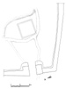
Fig. 10
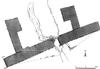
Fig. 11
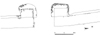
Fig. 12
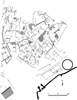
Fig. 7
Fig. 8
Fig. 5
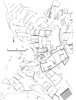
Fig. 6
Fig. 9
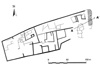
Fig. 14a

Fig. 14b
Fig. 3
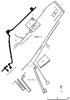
Fig. 13 |