OVERVIEW OF THE RE-EVALUATION OF EVIDENCE
Geoffrey
Summers
| Kerkenes Home | << | Previous Page | Next Page | >> | Back to Contents Page | |
| Preliminary Reports | Türkçe Çeviri | |||||
|
OVERVIEW OF THE RE-EVALUATION OF EVIDENCE |
||||||
|
|
|
|
|
|
||||||
| Figure 1 | Figure 3 | Figure 4 | Figure 5 | Figure 6 | Figure 7 | ||||||
|
|
|
|
|
|
||||||
| Figure 8 | Figure 9 |
Figure 10 | Figure 11 | Figure 12 | Figure 13 |
Defending seven kilometres of city wall, regardless of how imposing and
strongly built they may have been, would have posed logistical problems.
In this respect it might be relevant to remember that a considerable space
of variable width appears to run around the entire inner side of the defences
immediately behind the wall. Nowhere does this gap seem to measure less
than 5.00m. It is reasonable to think that such a space might have been
an integral part of any military design that depended on getting defending
forces to any particular point along the wall where an enemy attack might
be concentrated. If this interpretation is found to contain any merit,
it should be noted that the surface of this "military road"
was never made sufficiently smooth and level for mounted fighters, either
on horseback or in chariots. Foot soldiers on the other hand could be
quickly despatched from one place to another.
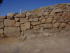
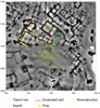
At what we tentatively continue to name the "Palace Complex" there is good evidence on which to suggest that an original defensive complex (Structure A in earlier reports), comprising massive towers retained by a stone revetment closely resembling both the scale and the style of defences at the Cappadocia Gate, underwent one or more major alterations. Both sides of the stone glacis were cut through, that on the north for the insertion of the northern wall to the Palace Complex and that on the south for the construction of a series of massive terraces (Structure B). Exactly how the newly excavated Monumental Entrance to the Palace Complex (Fig. 7) is to be fitted into this picture requires further excavation. Currently available evidence suggests that the Monumental Entrance also predates the construction of Structure B but was constructed after the "Audience Hall" (investigated in earlier seasons). In any event, it can now be demonstrated that there were a minimum of two and perhaps three major phases of construction on a monumental scale. Supporting evidence was recovered from the excavation, in 2000, of structures C and D, which lay to the west of Structure A. Here it could be seen that considerable modifications had taken place between the construction of these two buildings and the calamitous fire. 3. Dendrochronology Part of a beam with 197 annual growth rings was recovered from the Monumental Entrance in 2002. It is hoped that further samples collected by Prof. Kuniholm and his team in 2003 will help to establish the date for the construction of the Entrance. In any event, preliminary evaluation does not appear to be inconsistent with an early sixth century date for the cutting of the main beam. 4. The Urban Plan Geophysical
survey at Kerkenes has revealed a plan of the entire Iron Age city in
remarkable detail. The electrical resistivity survey conducted in over
the last three years has provided particularly striking results. The precision
of this imagery has been fully demonstrated by the results from carefully
targeted excavation in the central sector of the city conducted in the
early part of the 2003 summer campaign (Fig. 8).
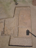
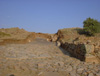
The results of the excavations in trenches TR06 and TR07 show that the
interpretation of the geophysical imagery, particularly the identification
of a true megaron (with an open porch and central hearth) was completely
correct. Within the excavated area there were found to be a minimum of
four phases of construction, the most substantial being the megaron (Fig.
1)
which was found to have been cut through an existing stone pavement. Evidence
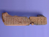
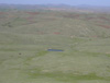
Bearing on the Date of the Foundation of the City The discovery of alphabetic or alphabetic-like letters inscribed on pottery found at the Palace Complex in 2001 as well as rows of marks on the faces of granite stones in the Ashlar Building first investigated in 2002 provided clues that pointed towards the not entirely unexpected presence of alphabetic writing at Kerkenes (Fig. 9). Completely unexpected, however, was the discovery in 2003 of fragments of one or more sandstone monuments that once stood in the Monumental Entrance to the large court in front of the "Audience Hall" at the Palace Complex. One or more of these monuments bear small-scale relief sculpture featuring winged lions and griffins together with figures in human form and inscriptions in Old Phrygian. For the moment the inscriptions and relief sculpture are not precisely dated, although it might be though somewhat perverse to suggest a date range wider than mid-seventh to mid-sixth century BC. on stylistic grounds (i.e. they appear to have neither Neo-Hittite nor Achaemenid characteristics). One of the inscriptions includes a dedication. The existence of these Phrygian inscriptions on one or more monuments would surely indicate the Anatolian character of Pteria, whether or not it was actually under some form of Median control at the time when the dedication was made. It is particularly noteworthy that the monuments appear to have been standing up until the time of the destruction, regardless of the date at which they were created. Prof. Claude Brixhe, in his preliminary analysis, confirms the Phrygian character of the inscription. 2. Artefacts and Ceramics This is a thorny area at a time when the date of the destruction level at Gordion has been convincingly raised by about 100 years. It has been recognised for some time that a certain amount of pottery and the repertoire of arrowheads at Kerkenes have close parallels with the finds from the Küçük Höyük at Gordion (the destruction of which is still most plausibly equated with the passage of Cyrus the Great in about 547 BC). In addition, however, Kerkenes has produced a few sherds, none of which come from good primary contexts, of black-gloss ware with raised lozenges and incised decoration. At Gordion pottery of at least superficially similar appearance is known from the South Cellar which is thought to date to some time before the end of the seventh century (Mary Voigt and Keith DeVries pers. comm.), although it is perhaps relevant that pottery of this type is not known from any of the tumuli at Gordion. In this regard it is perhaps salient to remember that when the current series of campaigns at Kerkenes began in 1993 it was assumed that the main period at the site would be found to fall in the eighth century and, according to the chronological schemes which were then generally accepted, it was (erroneously) expected that much of the material culture, especially the ceramics, would closely parallel the well known local repertoire from Alisar Höyük, which lies only 23km from Kerkenes, and particularly from the period known as Alisar IV. Current opinion on the date of Alisar IV is in some ways related to the revision of the sequence at Gordion as well as to the results from recent campaigns at Göllü Dag, discussion of which falls beyond the scope of this report. Two fibulae from the current work at Kerkenes (in addition to those found by Schmidt in 1928) also find parallels with Gordion that might support a date earlier than the sixth century. Excavations in the lower central area at Kerkenes produced several three-footed stone bowls. Similar bowls are known from the City Mound and Tumulus J at Gordion, the latter tentatively dated to the later seventh century, and from Midas City. No decorative revetment or roof tiles have been discovered at Kerkenes. The decision to excavate half of the megaron, in trench TR07, at the start of the 2003 season was partially influenced by the idea that if tiles of the types well known from Gordion, Pazarli and elsewhere had been used at Kerkenes there seemed to be a high probability that they would be found in association with this megaron. It can now be asserted, with not inconsiderable confidence, that decorative tiles were not used at Kerkenes. The precise chronological implications of this observation are a matter for further discussion since the date of the earliest such tiles at both Sardis and Gordion, together with the date of those rock-cut façades in the Highlands of Phrygia that appear to depict both tiled roofs and tiled façades, is far from settled. In this context it should not however be forgotten that the site of Pazarli lies only some 70km from Kerkenes as the crow flies. Conclusion on the Date of Foundation There is no good evidence that can be used to suggest how much time might have elapsed between the mid-sixth century destruction of Kerkenes, still in all probability to be identified with Pteria, and the foundation of the city. All that can be said at this interim stage is that there is no good reason to squeeze the foundation date into a period after the fall of Assyria although, by the same token, there is little to suggest a very much earlier date. Anatolian Characteristics of the City It might now be thought useful to list briefly the Anatolian characteristics that can be identified at Kerkenes. 1. Planned Mountain-top Sites Before the commencement of the first, 1993, season at Kerkenes it was thought likely that the site would turn out to be similar to the very elevated and clearly special site on the Göllü Dag in central Cappadocia. It was a happy coincidence that Prof. Schirmer's first season of exploration at Göllü Dag also took place in 1993. There are, we now know, clear differences between the two sites, not least in their function and their date, which it would be tedious to enumerate. The point to make here is that Göllü Dag does provide a good parallel for impressive stone defences following the rim of a mountain-top and for centralised rectilinear planning of the enclosed space. If more were known about other urban centres on the central plateau of Anatolia it might be found that, although the largest, Kerkenes fits into an Anatolian tradition of Iron Age city planning, the study of which remains in its infancy. Late Bronze Age antecedents for this tradition can be discerned at Hattusa itself and at other Imperial Hittite centres, most notably Ortaköy (Šapinuwa) and Kusakli (Sarrisa) near Sivas. Indeed the entire aspect of Hattuša is very like that of Kerkenes. 2. Defensive Systems Göllü Dag, as mentioned in the previous section, exhibits some similarities with Kerkenes, not the least of which is the way in which the circuit wall follows the rim of the crater as well as the discrete planning of each gate in order to make the best possible use of the immediate topography. The particular construction of stone defences at Kerkenes are however unique, both in their size and in the design of the granite glacis (Fig. 10). That said, however, the concept of a stone-faced glacis attains its apogee at the Upper City of Hattuša, where it reaches huge proportions. Perhaps less well known is that a similar but smaller stone glacis can be found, amongst other places, in the Iron Age defences at the Südburg (at Bogazköy). 3. Water Management At Kerkenes water resources were carefully managed (Fig. 11). As well as the stone-lined Sülük Göl on the high southern ridge and the very large Büyük Göl in the centre of the city, tiers of reservoirs are found both inside and outside the city, often constructed according to a sophisticated system of bank-side storage,. Most or all of these reservoirs were primarily designed to be filled by underground seepage rather than rain-fed runoff. Similar systems can be observed in the Hittite management of water resources at Bronze Age Hattuša where artificial pools also appear to have been fed by underground seepage. 4. Architecture The identification, on resistivity imagery, of two megarons, that is, of two buildings each comprising a large room with a central hearth, an open porch and a pitched roof, and the confirmation of this interpretation through the excavation of trench TR06 in July 2003, provides indisputable evidence for western Anatolian influence at Kerkenes (Fig. 1). This result comes in addition to the evidence for the double-pitched roofing of the Audience Hall which was obtained in 2002. Not all buildings, however, necessarily had pitched roofs, either in the Palace Complex or in the lower area of the city. In the Ashlar Building and in test trench TT19, both within the Palace Complex, as well as in test trench TT16 in the centre of the city, evidence has been found for roofing made of mud and reeds. In these cases, however, it remains possible that some rooms possessed upper floors or balconies and that the entire building had a pitched roof covered with thatch. At the northern end of the site, where in 1996 a columned hall was partially exposed in test trench TT15, much evidence for mud and reeds from a flat roof was also recovered. The new evidence from the Palace Complex, however, raises the question of whether the columned halls at the northern end of the city might perhaps have been provided with a second storey, as well as how precisely the form of the roof should be reconstructed. The possibility that columned halls at Kerkenes represent an Iranian presence must, therefore, be left open, even though much doubt might be cast on it. With regard to details of construction techniques, at the Monumental Entrance to the Palace Complex it has been found that some, and perhaps most, of the large sandstone blocks were secured together with the aid of wooden clamps (Fig. 12). The date of the first use of such clamps in Central Anatolia is not clear, but I do not know of any examples from Gordion or Bogazköy. Nor are there any such clamps in Urartu. At Sardis the earliest clamps are found in a few of the blocks in the Tomb of Alyattes, but these appear to have been entirerly lead filled (Crawford Greenewalt pers. comm.). The Kerkenes clamps vary in size, but not in depth, even where two occur on the same face of the same stone. The form resembles the swallow-tailed rather then the dovetailed variety, although the sides are sometimes slightly curved. It is generally assumed that iron bars were fixed into these wooden clamps, as they were later fixed into lead, but no such iron clamps have been recovered from amongst the large number of very well preserved iron building elements which were found in the burnt debris. Yet other cuttings in the sandstone blocks appear to represent additional forms of fixing that employed squared wooden elements, but the sandstone blocks were smashed and usually shattered, with the result that it has been difficult to reconstruct the precise form of these cuttings. 5. A Stepped Shrine with an Aniconic Stele of a Phrygian Deity inside the Cappadocia Gate This completely unexpected discovery, which has not yet been fully excavated, provides clear evidence for the presence of an Anatolian cult at Kerkenes. The shrine is located in the rear part of the gate passage adjacent to the north-west wall of the inner, north-eastern, tower. The steps continue down below the level at which excavation was halted in 2003. The edifice comprises a series of steps, rather poorly constructed of rough granite, with a top step and a stele both made from a chalky stone which has shattered as a result of the fire and the collapse of the adjacent tower. The top step has a recess into which the stele was snugly fitted. It might well be assumed that there was a matching slab at the rear which, together with the smashed back of the stele itself, was broken during the destruction of the gate. 6. The Extra Mural Temple at Karabas Without mustering again the arguments concerning the huge monument at Karabas, which is located about 1km due north of the northernmost tip of the city (Fig. 13), being a cult structure of some kind, it is worth remembering that Hattuša too has an extra mural cult site and temple at Yazilikaya, and that many open air shrines, all be they of somewhat different character, are known from several parts of Phrygia. On the other hand, the plan of Karabas is not paralleled in Anatolia whereas the corner buttresses are similar in concept, if not in scale, to smaller monuments in Urartu and Iran. 7. Tumulus Burials Tumulus
burials of various type, dating from the Iron Age to the Hellenistic or
Roman period, abound in Central Anatolia. There is, however, a particularly
heavy concentration of tumuli, some of which were certainly for cremation,
on the ridges to the west of Kerkenes (Fig. 13).
It may be safely presumed that most if not all of these tumuli are associated
with the city, although that does not mean that all of the inhabitants
were buried in the same way. Tumuli are, of course, characteristic of
the Gordion Ankara region of Phrygia in the Iron Age.
|
| Kerkenes Home | << | Previous Page | Next Page | >> | Back to Contents Page |
| Preliminary Reports | Türkçe Çeviri | ||||