|
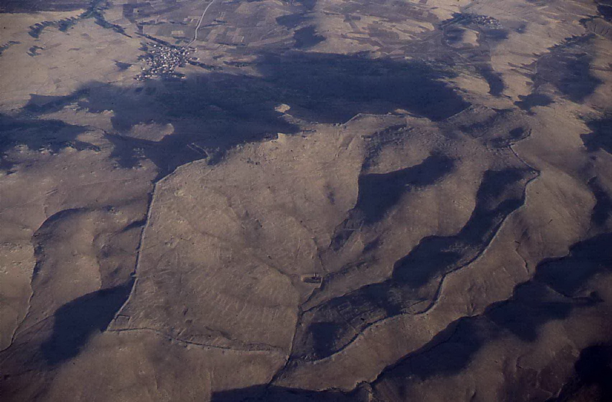
Kerkenes was ancient
Pteria, founded by the Median king Aystages, following the “Battle
of the Eclipse”, 28th May, 585 BC. According to Herodotus, Croesus
destroyed it in 547 BC, following his divinely sanctioned crossing of
the Halys, in the mistaken belief that he would destroy the Persian Empire
rather than his own. Croesus enslaved the Pterians and chased innocent
Cappadocians from the surrounding countryside. Lydian aggression was soon
halted by the Achaemenid usurper Cyrus the Great at the indecisive “Battle
of Pteria”, fought on the plain below. Pteria is the largest Iron
Age city on the Anatolian Plateau, its prominent peak dominating the landscape.
Central location provides the key to understanding both its choice as
the western capital of the Median Empire and the brevity of its magnificence.
Few references occur in the ancient sources: Herodotus locates Pteria
east of the Halys River (modern Kizilirmak) and describes it as the strongest
place in that part of Cappadocia. The Byzantine geographer Stephanos knew
it to have been a city of the Medes. Our research has shown that Median
Empire possessed the ostentation typical of ancient empires and put in
place a system of control that facilitated consolidation and expansion
of Iranian power under the Achaemenids. |
|
M.Ö. 28 Mayıs
585 günü yapılan "Güneş Tutulması Savaşı"nın ardından Med kralı Astyages
tarfından kurulan antik Pteria kenti Kerkenes olmalıdır. Heredot'a göre,
M.Ö. 547 yılında Kızılırmağı geçtiğinde yıkılacağı kehanetinde bulunulan
bir imparatorluğun kendisininki değil de İran'dan gelen Medlerinki olduğu
düşüncesiyle şehre saldıran Krezüs tarafından yok edilmiştir. Krezüs Pterialıları
esir etmiş ve çevrede yaşayan Kapadokyalıları yurtlarından sürmüştür.
Akamanış hükümdarı Büyük Keyhüsrev, şehrin etrafındaki düzlükte yapılan
"Pteria Savaşı" ile Lidyalıların harekatına son vermiştir. Zirvesi çevreye
hakim bir konumda bulunan Pteria, Anadolu platosunda bulunan en büyük
Demir Çağı kentidir. Bu merkezi konumu, neden Med İmparatorluğunun batıdaki
başkenti olarak seçildiğini ve bu yüceliğinin neden bu kadar kısa sürdüğünü
açıklamaktadır. Eski Çağ kaynaklarında bulunan göndermelerden bazıları
şunlardır: Heredot'a göre Pteria, Halys Irmağının (Kızılırmak) doğusunda
bulunmaktadır ve Kapadokyanın en iyi korunan şehirdir. Bizanslı coğrafyacı
Stephanos da şehrin Medlerce kurulduğunu söylemektedir. Araştırmalarımız
Med İmparatorluğunun da diğer eski çağ imparatorlukları gibi gösterişi
sevdiğini ve İran hakimiyetinin daha sonra Akamanışlar tarafından yayılmasını
sağlayan bir kontrol sistemi oluşturmayı başardığını göstermiştir. |