| |
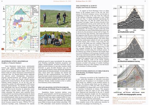
THE GEOPHYSICAL SURVEY
Geoffrey and Françoise Summers
In support of Scott Branting's focus on urban blocks in the northern sector of the city, the 2011 season of electrical resistance survey was devoted to completing coverage of the area from the north tip of the defences extending southwards to the 2300m north axis (Fig. 3). Space precludes reproducing the entire image here, for that the reader must turn to the project web page. Figure 4a shows the plot of the earlier gradiometer survey at the north end, 4b is the electrical resistance map of the same area, and 4c is a 3D microtopographic GPS image with some structures superimposed. The lozenge of space inside the north tip, where there are stone-walled animal pens still in use as shown by the prominent curved wall in Figure 4b, is devoid of Iron Age structures. This result reinforces the suggestion that this area, which lies behind a strong stone tower on the north tip of the city defences, had a military function facilitating defence. The entire slope inside the northwestern stretch of wall was occupied by urban blocks. One of these, lying along the city wall east of the 800m east axis, contains a large hall, possibly a temple, where test trench TT15 was dug in 1996. This urban block is the central focus of the new program initiated by Scott Branting. The two urban blocks revealed along the northeast section of the defences are similar in character and include large two-room buildings as well as groups of smaller rooms which may represent households within the compound. The northernmost block does not display any features to support the suggestion that it had a military function. Finally, the imagery south of the stream running towards the Water Gate revealed an area of different character crowded with groups of smaller buildings separated by alleyways. Here, perhaps, were the houses and workshops of ordinary people.
NEW INVESTIGATIONS IN AN URBAN BLOCK
Scott Branting, Sevil Baltalı Tırpan, Joseph Lehner
Following excavations in the Cappadocia Gate, a new multi-year program of wide-area excavation began this year. Its purpose is to investigate an entire urban block (ca. 6000m2) in the northern portion of the city. The selected urban block was the subject of limited excavations in 1996 and 1998, which yielded the remarkable ivory plaque that is now in the Museum of Anatolian Civilizations in Ankara. This program is designed to shed new light on how urban blocks were organized and functioned in the city. It should also provide important insights into the organization of households within the city in terms of what they consumed and produced as well as the larger social networks within which they participated.
Excavations this year in trench TR29 exposed three complete rooms of the multi-room structure in which the ivory plaque was found (Fig. 9).
|