| |
Figure
6: Resistivity survey conducted over a carefully selected
area of one hectare. The results, which are influenced by hydrology
rather than geology, show certain details with greater clarity than
gradiometer survey.
Figure
7: A gradiometer survey of the same area highlights the effects
of destruction by fire and also records the underlying geology.
Figure
8: A first experiment over the same area with electromagnetic
conductivity hints at future potential.
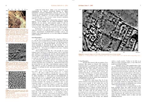
Figure
9: A magnetic image, over 80 x 60m,
showing parallel rows of rooms at right.
Urban Dynamics
Of particular interest is the recognition
of two buildings that appear as though they might be megarons
(Fig. 6).
A megaron is a type of building characterised by a pitched
roof, open porch and central hearth that has clear cultural connections
with Phrygia. These two structures, both apparently laying outside
any of the original urban blocks, are substantial buildings each measuring
approximately 10 x 12m. The existence of these megarons may
perhaps represent further evidence for increasing Anatolianisation
of the city in the years leading up to its destruction around 547
BC.
A single 80 x 60m image (Fig. 9)
of sub-surface remains in the central portion of the site may serve
as an example of the results that can be replicated over the greater
part of the very large surveyed area. A section of a street can be
seen meandering along a contour at bottom left and a heavily burnt
set of structures stand out to the left of centre. At centre right
are two parallel rows of rectangular rooms, each some 6 x 4m, with
a corridor between. The row on the left appears to be longer than
that on the right. Such a large number of these cells, which were
presumably for storage, are unusual within a single complex. Further
to the left, in an otherwise empty rectangular space, is one of the
more usual two-roomed buildings.
Magnetic survey in the central portion of the city has led to the
identification of a large, open, public place. One possible function
for this feature could well have been as a market place, for which
no other good candidate has been recognised within the city walls.
Several major streets run tangentially to this space at the north-east
of the Büyük Göl, the largest of the artificial reservoirs within
the city. This large level area, which must have been devoid of buildings
for some special purpose, occupies a sheltered position in the central
sector of the site. New imagery of the Büyük Göl itself, obtained
in September when it was dry, revealed the presence of substantial
stone walling within the artificial banks on all four sides.
Unlike the Sülüklü Göl (Leech Pond) on the high southern ridge, also
fully surveyed when completely dry, the Büyük Göl does not seem to
have an elaborate and carefully constructed stone lining. Although
part of an overall, planned, scheme of urban water management, the
various pools and reservoirs within the city evidently varied in status
and had differing functions.
|
|