| |
TRANSPORTATION STUDIES
Scott Branting
The program of innovative transportation studies, fi rst reported in the 2004 Kerkenes News, has been expanded over the past two years. Its purpose is to leverage the information gained from the plan of the city, reconstructed from years of remote sensing survey, in order to understand how the city was once used by its inhabitants. Utilizing computer simulations that place virtual people back into the streets and buildings within this plan of the ancient city, we are able to understand better how the city as a whole functioned as well as the purposes of particular structures. The results can then be used to guide more precisely future excavations and to tie the information gained from the excavations back into broader citywide contexts.
The original computer simulations reported on in 2004 were undertaken using a special type of Geographic Information Systems (GIS) software used by transportation planners and urban designers known as GIS-T. The software, as modifi ed for the project, brings together very detailed medical models of how different types of people walk within the physical topography and environment of a city or region. It was tested against a modern example, the city center of Cambridge in England, where the results of the computer simulations could be checked against direct observations of people as they walked around the city. Results showed that the simulations accurately predicted people's movement within the city plan.
In 2007, a Joint Theory Institute grant was secured to port the GIS-T methodology over into an Agent-Based Modeling (ABM) framework. Using Repast Simphony, a free and open-source ABM toolkit, we have been able to produce a working prototype that is in the fi nal stages of development. Named SHULGI, this new ABM software will allow much greater fl exibility in the sorts of simulations that can be run in order to explore the day-to-day activities of the people who once lived within this city. It will also cost nothing to acquire, unlike the commercial GIS-T software, making it more readily available to other archaeological projects or even modern urban planners who wish to design cities and neighborhoods more accessible to pedestrian traffi c.
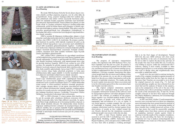
Funds were also provided to continue testing the results of the computer simulations against measures of ancient traffi c pulled from the Iron Age city streets at Kerkenes Dağ. Trenches are excavated so as to bisect the original unpaved city streets (Fig. 17). Soil and micromorphology samples are then collected from the street bed and the analysis of factors in the samples, such as the compactness of the soil or the size of the soil particles, have shown promising correlations with the results of the simulations (Fig. 18 and 19). All the samples collected so far have been analyzed through the Charles McBurney Laboratory for Geoarchaeology at Cambridge University.
In 2007 and 2008, a further 13 such transportation trenches were excavated and over these two campaigns more information has been gained about the patterns of erosion along the city streets, an increasing number of these trenches have yielded preserved sections of the Iron Age streets that could be successfully sampled. The samples taken from these contexts are providing an expanding statistical sample against which to continue to test the results of the computer simulations. They are also providing the basis for developing a completely new way to analyze archaeologically how the inhabitants once made use of the places within this ancient city.
|