
RESULTS
1. Cadastral survey.
Cadastral survey concentrated on those steeper and more difficult areas
of the site that, for logistical reasons (steepness of slope, proximity
of bed-rock to the surface and large bed-rock outcrops, erosion of cultural
features), will not be subject to large area geophysical survey in future
seasons, and on the zone of "Public Buildings" in order to resolve particular
functional and architectural problems. The preliminary results are shown
on Figs 5, 6,
7, 8
and 9. The programme of interpretation
of these results and the combination of the cadastral plans with geophysical
data and rectified balloon photographs will continue through the winter
and spring of 1997/98. Completion of the city map, showing communication
routes, urban zoning, water resources and management is within sight.
A longer term goal, spatial analysis leading towards an increased understanding
of the urban dynamics through GIS is also underway.
A number of points have been confirmed or become clearer during the
course of the season:
-
All of the
urban space was being utilised by the time of the catastrophic fire
(? at the hands of Croesus c. 547 BC) that brought the life
of the city to an abrupt end;
-
The intensity
of the destructive fire, seen in test trenches dug in 1996, extended
over the whole of the city;
-
Erosion has
denuded much or all of the cultural material from the steeper slopes,
with the exception of stone wall foundations.
- The substantial preliminary
report published in A nato/ian Studies for 1996 will require only
minor modification, but considerable addition and expansion (which
is, after all, the whole point of continuing the field work), but
is essentially correct in all matters of importance, e.g. the absence
of internal defensive walls, the date of the destruction, the architectural
affinities (or lack there of), the nature of the city as a new imperial
foundation, the division into urban blocks as a result of centralised
division of urban space and its enclosure (= city planning).
2. City Defences.
Completion of the detailed plan of the city defences, with individual
plans and descriptions of the city defences was fully achieved (Figs
10, 11
and 12).
A major discovery was a new gate on the eastern side of the north-east
section of the city wall, described in detail below. It is now thought
probable that the "Water Gate" was not in fact a gate but a very heavily
fortified section of the city defences at the weakest point in the circuit.
If there was a gate here it can only have been a foot passage. The total
number of city gates would thus appear to have been seven, a number
that might well have had special significance. Specific architectural
questions concerning the gates have been at least partially answered,
particularly the way in which the sloping glacis that encloses the outer
face of the defensive system at the gates has been resolved. In general,
the unique form and skilful military design of each gate that incorporated
the naturally defensible advantages of each individual position and
its topography have been further elucidated. An outstanding problem
is the width of the gate-passages, averaging about 8m, and how the superstructure
of the gates was carried, or intended to be carried over them. Only
partial clearance of a gate will eventually answer this question.
3. Zone of "Public Monuments
".
Planning and description of the "public zone" (Figs 13,
14a and 14b),
comprising the "palace complex", the stone-lined Suluklu Gol (leech
pond), "imperial stables" or "store houses", the approach from the "Cappadocia
Gate", the "military area", the "administrative block", the "polo field"
and associated structures and the "stone circle" was completed.
The survey was carried out by a combination of techniques that included
ground truthing balloon photographs, flagging and surveying walls visible
on the surface, and further geomagnetic mapping. Specific goals were:
(a) to ascertain whether the features that appeared on previous incomplete
geomagnetic maps of the street leading from the "Cappadocia Gate" to
the façade of the "Palace Complex" required a re-interpretation
of this area and, (b), to see if there were any ancient structures in
front of the putative monumental entrance to the "Palace Complex" which
might have necessitated a re-interpretation.
A preliminary description and discussion is provided below (Appendix
1). This has greatly enhanced our knowledge and understanding of
this huge and critical area of the city.
4. Object Conservation,
Drawing and Photography.
Conservation of all material from every season was completed in spite
of the early departure of our conservator, Ms Simone Korolnik, as a
result of the traffic accident. We were also pleased to have been able
to clean and restore a small number of Early Bronze Age decorated pottery
vessels from the rescue excavations at Mercimek Tepe (Yozgat city) conducted
by Sayin Musa Ozcan, Director of the Yozgat Museum.
All the material from Kerkenes itself was drawn and photographed, in
colour, black and white and much of it, for the Kerkenes World Wide
Web page, with a digital camera. Most of the pottery from the regional
survey has also been drawn. Outstanding is an expert examination of
the iron pieces excavated in the "columned hail" in 1996 (probably wheel
parts), and a very small amount of object photography.
5. Geophysical Research.
Geomagnetic survey was carried out over two 40 x 40m grids (Fig. 20a
and 20b) at a sample density of
8 readings per meter at 0.25m intervals in parallel (not zigzag) so
as to provide the best possible data set for the development of processing
software and also future sampling strategies at Kerkenes. The significance
of this work for the development of geophysical data processing goes
beyond Kerkenes itself which is a natural laboratory for the development
of these techniques. The images on Fig. 20 were processed in the field,
Lewis Somers is currently reprocessing this data together with that
from previous seasons, in his pre-release version of GEOPLOT 3. Much
greater clarity is anticipated, together with the re-evaluation of features
not yet readily apparent.
The two areas selected for this intensive survey were chosen because
coarser sample density collection in 1996 had shown that there were
well preserved sub-surface remains that yielded signals not obscured
by geological features or by really massive destructive burning. The
second of the two areas (Fig. 20b)
was also selected to test the hypothesis that there was a columned hall
here, with negative but not conclusive result.
A new plan of Area D, incorporating new geophysical data with that collected
in previous seasons and checked against surface features was drawn (Fig.
21)
6. Kite Photography.
A small portion of the city is without low level balloon photographs
suitable for rectification in the composite mosaic (Fig. 1).
Experiments with a kite borne camera made good the deficit.
7. Geomorpho/ogica/ and
Geological Studies.
Study of the geological formation and composition of the Kerkenes Dag
was undertaken in the field. Thin section and compositional analyses
of the granitic rock and geological issues concerning geomagnetic survey
at Kerkenes is continuing in the Department of Geology at METU. Relationships
between the geology, hydrology, regional settlement patterns and urban
planning were examined with positive results. The nature of the Kerkenes
soils in relation to geomorphological evolution of the landscape and
to patterns of erosion following the destruction and abandonment of
the city were elucidated.
8. Later Periods.
A report on the Kale and other later features, (Figs 3-4),
will be submitted to A nato/ian Studies. A report on the Hellenistic
to Byzantine pottery from the Kiremitlik and Kale is being prepared
by A. Goldman (as an appendix to the above or as a paper in its own
right).
9. The Monograph.
Substantial progress has been made in the production of a monograph.
(Appendix 3)
10. Micromorphology.
Dr Wendy Matthews continued study of the samples that she took for micromorphological
research in 1996. The results have enabled assessment of the value of
these techniques in the development of future research design at Kerkenes.
A preliminary report by Dr. Matthews forms Appendix
2.
|
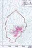
Fig. 5
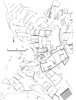
Fig. 6
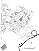
Fig. 7
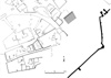
Fig. 8

Fig. 9
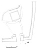
Fig. 10
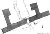
Fig. 11

Fig. 12
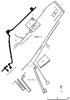
Fig. 13
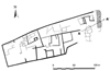
Fig. 14a

Fig. 14b
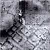
Fig. 20a
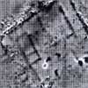
Fig. 20b
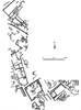
Fig. 21
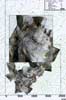
Fig. 1
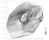
Fig. 3
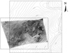
Fig. 4
|
